IMAGES TAKEN NEAR TO
Wedgwood Road, MANCHESTER, M27 8RT
Introduction
This page details the photographs taken nearby to Wedgwood Road, M27 8RT by members of the Geograph project.
The Geograph project started in 2005 with the aim of publishing, organising and preserving representative images for every square kilometre of Great Britain, Ireland and the Isle of Man.

There are currently over 7.5m images from over14,400 individuals and you can help contribute to the project by visiting https://www.geograph.org.uk
Image Map
Images are licensed for reuse under creativecommons.org/licenses/by-sa/2.0
Notes
- Clicking on the map will re-center to the selected point.
- The higher the marker number, the further away the image location is from the centre of the postcode.
Image Listing (19 Images Found)
Images are licensed for reuse under creativecommons.org/licenses/by-sa/2.0
Image
Details
Distance
3
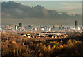
Manchester
Manchester City Centre seen from Clifton Green.
Image: © Peter McDermott
Taken: 22 Nov 2014
0.07 miles
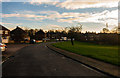
4

Clifton Green
Houses on Clifton Green.
Image: © Peter McDermott
Taken: 22 Nov 2014
0.11 miles
5
Falcon Crescent
Falcon Crescent on Pepper Hill.
Image: © Peter McDermott
Taken: 22 Nov 2014
0.15 miles
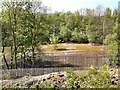
6

Clifton Hall Colliery
Old railways sidings at the site of Clifton Hall Colliery.
Image: © Peter McDermott
Taken: 14 Oct 2017
0.22 miles
7
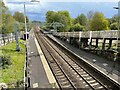
Clifton railway station, Greater Manchester
Opened in 1847 by the East Lancashire Railway, soon to become the Lancashire & Yorkshire Railway, this was a junction station until 1966. The line from Accrington came in beyond the end of the left hand platform, and there were two more platforms and a station building to the extreme left of the image, now hidden by trees.
View SE towards Salford. Although the line has been electrified since Image was taken from a similar position some eight years earlier, still only a handful of trains per day called here at the time this image was taken.
Image: © Nigel Thompson
Taken: 6 May 2021
0.23 miles
8
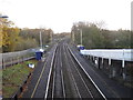
Clifton railway station, Greater Manchester
Opened in 1847 by the East Lancashire Railway, soon to become the Lancashire & Yorkshire Railway, this was a junction station until 1966. The line from Accrington came in beyond the end of the left hand platform, and there were two more platforms and a station building to the extreme left of the image, now hidden by trees.
View SE towards Salford. Seven years later, the line was electrified - see Image for a 2021 view taken from a similar position. Only a handful of trains per day called here both before and after electrification.
Image: © Nigel Thompson
Taken: 17 Nov 2012
0.23 miles
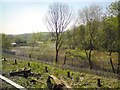
9
An overgrown car park
South of Clifton station.
Image: © Gerald England
Taken: 8 May 2018
0.23 miles
10
Site of former factory
Off Lumns Road south of Clifton station.
Image: © Gerald England
Taken: 8 May 2018
0.23 miles