IMAGES TAKEN NEAR TO
Rake Lane, MANCHESTER, M27 8RA
Introduction
This page details the photographs taken nearby to Rake Lane, M27 8RA by members of the Geograph project.
The Geograph project started in 2005 with the aim of publishing, organising and preserving representative images for every square kilometre of Great Britain, Ireland and the Isle of Man.

There are currently over 7.5m images from over14,400 individuals and you can help contribute to the project by visiting https://www.geograph.org.uk
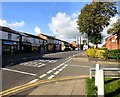
Image Map
Images are licensed for reuse under creativecommons.org/licenses/by-sa/2.0
Notes
- Clicking on the map will re-center to the selected point.
- The higher the marker number, the further away the image location is from the centre of the postcode.
Image Listing (11 Images Found)
Images are licensed for reuse under creativecommons.org/licenses/by-sa/2.0
Image
Details
Distance
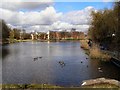
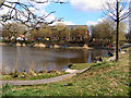
3
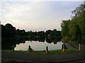
Queensmere
A popular fishing spot in Swinton. SD78130262
Image: © Keith Williamson
Taken: 30 Aug 2005
0.19 miles
4
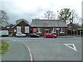
Clifton Library and Community Centre, Wynne Avenue, Swinton
Image: © Alexander P Kapp
Taken: 27 Apr 2012
0.21 miles
5
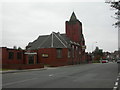
Clifton, Church for Sale
On Bolton Road; nothing visible showing what sort of church it was, but Online Parish Clerk shows it as the Victoria Wesleyan Methodist Church. http://www.lan-opc.org.uk/Salford/Pendlebury/index.html
A local source reports that the church was built 1901-3, replacing an earlier chapel on Moss Lane; one of four Methodist churches in the area, now all gone.
Image: © Mike Faherty
Taken: 18 Oct 2009
0.22 miles
6
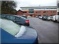
Oak Court, Swinton, Manchester
This development of office buildings is within sight of the M60, thus providing rapid communication with the motorways around Manchester and across the Pennines to Yorkshire.
Image: © John Goldsmith
Taken: 6 Dec 2011
0.23 miles
8
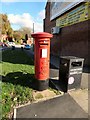
Edward VII Postbox (M27 48)
Outside Newtown Post Office on the corner of Bolton Road and Ramsden Fold.
Image: © Gerald England
Taken: 27 Oct 2017
0.24 miles
9
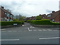
Bolton Road
The A666 through Newtown.
Image: © Gerald England
Taken: 27 Oct 2017
0.24 miles
10
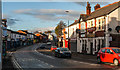
Bolton Road
Bolton Road at Newtown.
Image: © Peter McDermott
Taken: 22 Nov 2014
0.24 miles