IMAGES TAKEN NEAR TO
Hewer Close, MANCHESTER, M27 8BT
Introduction
This page details the photographs taken nearby to Hewer Close, M27 8BT by members of the Geograph project.
The Geograph project started in 2005 with the aim of publishing, organising and preserving representative images for every square kilometre of Great Britain, Ireland and the Isle of Man.

There are currently over 7.5m images from over14,400 individuals and you can help contribute to the project by visiting https://www.geograph.org.uk
Image Map
Images are licensed for reuse under creativecommons.org/licenses/by-sa/2.0
Notes
- Clicking on the map will re-center to the selected point.
- The higher the marker number, the further away the image location is from the centre of the postcode.
Image Listing (20 Images Found)
Images are licensed for reuse under creativecommons.org/licenses/by-sa/2.0
Image
Details
Distance
1

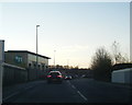
Trinity Point
The Trinity Point housing development.
Image: © Peter McDermott
Taken: 12 Nov 2016
0.01 miles
2
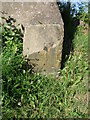
Old milemarker by Agecroft Road, Pendlebury
Milemarker by the Manchester, Bolton & Bury Canal, in parish of Salford (Salford District), Agecroft Road, Pendlebury. Broken.
Inscription reads:-
3
Surveyed
Milestone Society National ID: MBB-03
Image: © Milestone Society
Taken: Unknown
0.06 miles
3
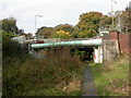
Kersal, pipeline
Pipeline running parallel to Agecroft Road, crossing the old Manchester, Bolton & Bury Canal.
Image: © Mike Faherty
Taken: 19 Oct 2009
0.07 miles
4
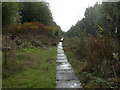
Kersal, towpath
Towpath along the Manchester, Bolton & Bury Canal, composed of large stone slabs. The canal (to the right) looks more like a marsh at this location. Watch the step ahead! http://www.penninewaterways.co.uk/mbb/index.htm
Image: © Mike Faherty
Taken: 19 Oct 2009
0.08 miles
5
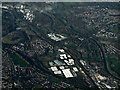
Pendlebury from the air
The distinctive shape of HM Prison Forest Bank can be seen near the centre of the photo. The large buildings in the foreground are at Agecroft Commerce Park. The River Irwell cuts diagonally through the scene. Part of Prestwich can be seen to the top right.
Image: © Thomas Nugent
Taken: 10 Nov 2014
0.09 miles
7
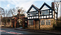
Northern Cemetery
Northern Cemetery at Pendlebury.
Image: © Peter McDermott
Taken: 22 Nov 2014
0.15 miles
8

Agecroft CEGB interchange sidings
A view from Agecroft power station's coal stocking area toward the connection with British Rail's Manchester-Bolton line, on which a class 40 diesel is passing at higher level. Immediately behind the steam locomotive is the pier for the large conveyor provided to take coal directly from Agecroft colliery to the electricity generating station.
Image: © Peter Whatley
Taken: 2 Apr 1976
0.16 miles
9
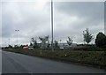
Tallyman Way, Agecroft, Greater Manchester
An industrial site on the former site of Agecroft colliery.
Image: © Steve Fareham
Taken: 26 May 2011
0.18 miles
10
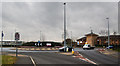
Roundabout marking the entrance to Agecroft Enterprise Park
Image: © Ian Greig
Taken: 13 Feb 2015
0.18 miles