IMAGES TAKEN NEAR TO
Rake Lane, MANCHESTER, M27 8BN
Introduction
This page details the photographs taken nearby to Rake Lane, M27 8BN by members of the Geograph project.
The Geograph project started in 2005 with the aim of publishing, organising and preserving representative images for every square kilometre of Great Britain, Ireland and the Isle of Man.

There are currently over 7.5m images from over14,400 individuals and you can help contribute to the project by visiting https://www.geograph.org.uk
Image Map
Images are licensed for reuse under creativecommons.org/licenses/by-sa/2.0
Notes
- Clicking on the map will re-center to the selected point.
- The higher the marker number, the further away the image location is from the centre of the postcode.
Image Listing (14 Images Found)
Images are licensed for reuse under creativecommons.org/licenses/by-sa/2.0
Image
Details
Distance
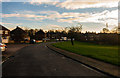
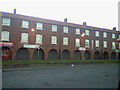
2

Clifton Green
Houses on Clifton Green.
Image: © Peter McDermott
Taken: 22 Nov 2014
0.04 miles
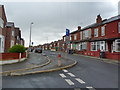
4
Falcon Crescent
Falcon Crescent on Pepper Hill.
Image: © Peter McDermott
Taken: 22 Nov 2014
0.13 miles
5
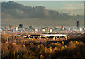
Manchester
Manchester City Centre seen from Clifton Green.
Image: © Peter McDermott
Taken: 22 Nov 2014
0.14 miles
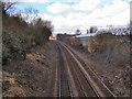
7
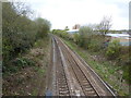
Railway northwest of Clifton Railway Station
Image: © Alexander P Kapp
Taken: 27 Apr 2012
0.24 miles
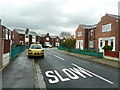
8
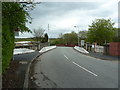
Pepperhill Bridge on Rake Lane, Swinton
Image: © Alexander P Kapp
Taken: 27 Apr 2012
0.24 miles
9
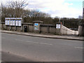
Clifton Station Entrance
The entrance to Clifton station, on Pepperhill Bridge.
Image: © David Dixon
Taken: 28 Mar 2010
0.24 miles
10
Railway at Clifton
Looking north-west from Pepperhill Bridge.
Image: © David Dixon
Taken: 28 Mar 2010
0.24 miles