IMAGES TAKEN NEAR TO
Lawefield Crescent, MANCHESTER, M27 6NW
Introduction
This page details the photographs taken nearby to Lawefield Crescent, M27 6NW by members of the Geograph project.
The Geograph project started in 2005 with the aim of publishing, organising and preserving representative images for every square kilometre of Great Britain, Ireland and the Isle of Man.

There are currently over 7.5m images from over14,400 individuals and you can help contribute to the project by visiting https://www.geograph.org.uk
Image Map
Images are licensed for reuse under creativecommons.org/licenses/by-sa/2.0
Notes
- Clicking on the map will re-center to the selected point.
- The higher the marker number, the further away the image location is from the centre of the postcode.
Image Listing (18 Images Found)
Images are licensed for reuse under creativecommons.org/licenses/by-sa/2.0
Image
Details
Distance
1
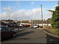
Lawefield Crescent
Part of an extensive estate on the edge of the Irwell Valley.
Image: © Jonathan Wilkins
Taken: 26 Dec 2016
0.04 miles
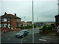
2
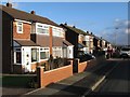
Outwood Avenue
Part of the extensive housing estate on the edge of the Irwell valley.
Image: © Jonathan Wilkins
Taken: 26 Dec 2016
0.06 miles
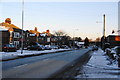
3
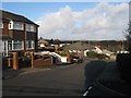
Outwood Avenue
Looking downhill towards Belmont Avenue. The location of this housing estate on the edge of the Irwell valley gives tantalising views not only to the wooded northern side of the valley, but to distant moorland.
Image: © Jonathan Wilkins
Taken: 26 Dec 2016
0.06 miles
4
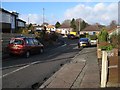
Westbourne Avenue
Bungalows on the downhill side of Westbourne Avenue, part of an extensive housing estate on the edge of the Irwell valley.
Image: © Jonathan Wilkins
Taken: 26 Dec 2016
0.07 miles
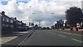
6
The A666: Manchester Road, Clifton
Taken towards evening on Christmas Eve.
Image: © Bill Boaden
Taken: 24 Dec 2010
0.12 miles
7
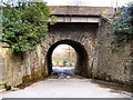
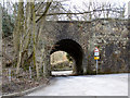
Doe Brow Bridge
The railway bridge at Doe Brow allows vehicular access to the Clifton Country Park.
Image: © David Dixon
Taken: 28 Mar 2010
0.14 miles
9
Doe Brow Bridge
The exit to Clifton Country Park.
Image: © David Dixon
Taken: 28 Mar 2010
0.14 miles
10
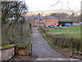
Clifton House Farm
The entrance to Clifton House Farm
Image: © David Dixon
Taken: 28 Mar 2010
0.15 miles