IMAGES TAKEN NEAR TO
Mossfield Road, MANCHESTER, M27 6EH
Introduction
This page details the photographs taken nearby to Mossfield Road, M27 6EH by members of the Geograph project.
The Geograph project started in 2005 with the aim of publishing, organising and preserving representative images for every square kilometre of Great Britain, Ireland and the Isle of Man.

There are currently over 7.5m images from over14,400 individuals and you can help contribute to the project by visiting https://www.geograph.org.uk
Image Map
Images are licensed for reuse under creativecommons.org/licenses/by-sa/2.0
Notes
- Clicking on the map will re-center to the selected point.
- The higher the marker number, the further away the image location is from the centre of the postcode.
Image Listing (21 Images Found)
Images are licensed for reuse under creativecommons.org/licenses/by-sa/2.0
Image
Details
Distance
1
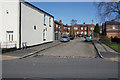
Kent Street
A short street with the original cobbles showing.
Image: © Bill Boaden
Taken: 5 Apr 2018
0.02 miles
2
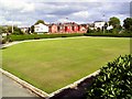
Clean Bowled
Well-manicured bowling green in Newtown Park, Swinton.
Image: © Roger May
Taken: 1 Sep 2005
0.07 miles
4
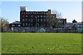
Lowry Mill
The mill is largely occupied by self-storage facilities, which seem to be greatly in demand currently. In the foreground is a school playing field and some allotments behind the fence.
Image: © Bill Boaden
Taken: 5 Apr 2018
0.13 miles
5
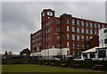
Lowry Mill
I doubt if that is its original name
Image: © Ian Greig
Taken: 13 Feb 2015
0.14 miles
6
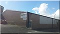
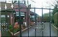
The Funhouse, Swinton
It is an indoor play centre located on Little Moss Lane.
Image: © Bradley Michael
Taken: 24 Sep 2015
0.17 miles
7
Lowry Mill
Formerly known as Newtown Mill, the five-storey building was constructed in 1883 as a spinning mill operated by John Knowles & Sons, and was more recently used by bedding manufacturer Dorma. It was acquired by Vanguard Holdings in 2008 who have converted it into office suites.
Image: © Gerald England
Taken: 27 Oct 2017
0.17 miles
8
Bolton Road
The A666 through Newtown.
Image: © Gerald England
Taken: 27 Oct 2017
0.21 miles
9
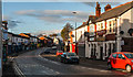
Bolton Road
Bolton Road at Newtown.
Image: © Peter McDermott
Taken: 22 Nov 2014
0.21 miles
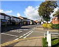
10
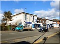
Station Road, Swinton
The white building on the left is Borough Social Club.
The building behind the bus stop on the corner of Dumbell Street is a Family Martial Arts Centre.
In between is "essence" which at the time this photograph was taken describes itself as a British Takeaway.
Note: Photograph is for record purposes only. The photographer has no personal connection with the businesses depicted.
Image: © Gerald England
Taken: 27 Oct 2017
0.22 miles