IMAGES TAKEN NEAR TO
Deacon Avenue, MANCHESTER, M27 6AR
Introduction
This page details the photographs taken nearby to Deacon Avenue, M27 6AR by members of the Geograph project.
The Geograph project started in 2005 with the aim of publishing, organising and preserving representative images for every square kilometre of Great Britain, Ireland and the Isle of Man.

There are currently over 7.5m images from over14,400 individuals and you can help contribute to the project by visiting https://www.geograph.org.uk
Image Map
Images are licensed for reuse under creativecommons.org/licenses/by-sa/2.0
Notes
- Clicking on the map will re-center to the selected point.
- The higher the marker number, the further away the image location is from the centre of the postcode.
Image Listing (32 Images Found)
Images are licensed for reuse under creativecommons.org/licenses/by-sa/2.0
Image
Details
Distance
1
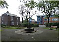
Memorial to Noah Robinson (rear view)
Erected in 1901 to commemorate Noah Robinson.
In the background is Swinton Police Station.
Image
Image
Image
Image: © Gerald England
Taken: 23 Sep 2022
0.08 miles
2
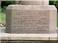
Memorial to Noah Robinson (front engraving)
The engraving reads:
ERECTED
TO COMMEMORATE THE SERVICES
RENDERED TO THE DISTRICT BY
NOAH ROBINSON
WHO FOR MORE THAN 36 YEARS
FILLED THE POST OF
GUARDIAN OF THE POOR
AND ALSO DISCHARGED MANY OTHER
PUBLIC DUTIES
IN A MANNER WHICH HAS WON FOR HIM
THE GRATITUDE AND ESTEEM
OF HIS FRIENDS AND NEIGHBOURS
1901
Image
Image
Image
Image: © Gerald England
Taken: 23 Sep 2022
0.08 miles
3
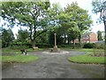
Memorial to Noah Robinson (front view)
Erected in 1901 to commemorate Noah Robinson.
It is set in the middle of Chorley Road Gardens.
Image
Image
Image
Image: © Gerald England
Taken: 23 Sep 2022
0.08 miles
4
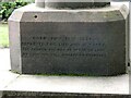
Memorial to Noah Robinson (rear engraving)
The engraving reads:
BORN JULY 18TH 1826,
DEPARTED THIS LIFE JULY 11TH 1907.
"FOR THOUGH THE DAY BE NEVER SO LONG,
AT LAST THE BELL RINGETH TO EVENSONG"
Image
Image
Image
Image: © Gerald England
Taken: 23 Sep 2022
0.08 miles
5
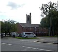
Corner of Union Street and Chorley Road
In the background is the tower of St Peter's Church.
Image: © Gerald England
Taken: 23 Sep 2022
0.13 miles
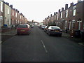
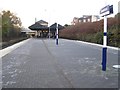
7
Swinton Station
Swinton Station on Station Road in Swinton.
Image: © Peter McDermott
Taken: 22 Nov 2014
0.14 miles
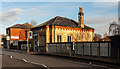
8
3d town map in display case
I photographed this approximately 1982 in its exact location. This appears to be a left over piece of history from when Swinton and Pendlebury were in Lancashire before being absorbed into Greater Manchester and the expanded city of Salford
Image: © Cliff
Taken: 1 Jan 1982
0.15 miles
9
Swinton (Manchester) railway station
Opened in 1887 by the Lancashire & Yorkshire Railway on its line from Manchester to Wigan, Southport and Liverpool. View west towards Wigan Wallgate.
Image: © Nigel Thompson
Taken: 17 Nov 2012
0.15 miles
10
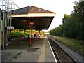
Swinton Railway Station
A view from the platform, looking towards Manchester.
Image: © Keith Williamson
Taken: 30 Aug 2005
0.16 miles