IMAGES TAKEN NEAR TO
Buttermere Avenue, MANCHESTER, M27 5WX
Introduction
This page details the photographs taken nearby to Buttermere Avenue, M27 5WX by members of the Geograph project.
The Geograph project started in 2005 with the aim of publishing, organising and preserving representative images for every square kilometre of Great Britain, Ireland and the Isle of Man.

There are currently over 7.5m images from over14,400 individuals and you can help contribute to the project by visiting https://www.geograph.org.uk
Image Map
Images are licensed for reuse under creativecommons.org/licenses/by-sa/2.0
Notes
- Clicking on the map will re-center to the selected point.
- The higher the marker number, the further away the image location is from the centre of the postcode.
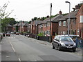
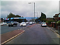
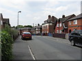
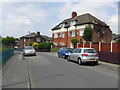
Image Listing (20 Images Found)
Images are licensed for reuse under creativecommons.org/licenses/by-sa/2.0
Image
Details
Distance
1
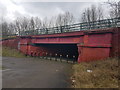
Underpass below the A580
The route of this path used to be a railway line.
Image: © Bradley Michael
Taken: 10 Mar 2017
0.06 miles
4
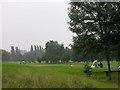
Swinton Park Golf Course
Taken from SD77900068, looking east. The home of Swinton Park Golf Club, originally Claremont Golf Club, founded in 1906.
Image: © Keith Williamson
Taken: 5 Sep 2005
0.10 miles
5
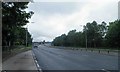
Heading west on the East Lancs Road, A580
Image: © Steve Fareham
Taken: 26 May 2011
0.10 miles
6
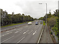
East Lancashire Road (A580), Swinton
Looking towards Salford and Manchester from Image
Image: © David Dixon
Taken: 30 Aug 2011
0.14 miles