IMAGES TAKEN NEAR TO
Goodwill Close, MANCHESTER, M27 5WP
Introduction
This page details the photographs taken nearby to Goodwill Close, M27 5WP by members of the Geograph project.
The Geograph project started in 2005 with the aim of publishing, organising and preserving representative images for every square kilometre of Great Britain, Ireland and the Isle of Man.

There are currently over 7.5m images from over14,400 individuals and you can help contribute to the project by visiting https://www.geograph.org.uk
Image Map
Images are licensed for reuse under creativecommons.org/licenses/by-sa/2.0
Notes
- Clicking on the map will re-center to the selected point.
- The higher the marker number, the further away the image location is from the centre of the postcode.
Image Listing (15 Images Found)
Images are licensed for reuse under creativecommons.org/licenses/by-sa/2.0
Image
Details
Distance
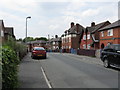

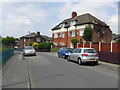
4
Grasmere Road, Swinton, Looking West
Part of an estate named after charming Lake District locations: presumably not intended to be ironic.
Image: © Peter Whatley
Taken: 1 Jul 2009
0.14 miles
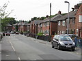
7
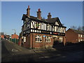
The Park Inn, Swinton
Nothing more needed to draw one inside than the Joseph Holt brewery sign. One of the many Holt establishments in the area.
Image: © al partington
Taken: 13 Dec 2007
0.17 miles
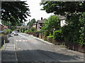
9
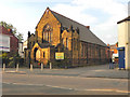
Manchester Road Methodist Church, Swinton
Image: © David Dixon
Taken: 9 Oct 2010
0.20 miles
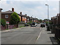
10
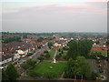
View from Salford Civic Centre Clock Tower
Image: © Anthony Parkes
Taken: 1 May 2000
0.21 miles