IMAGES TAKEN NEAR TO
Worsley Road, MANCHESTER, M27 5SN
Introduction
This page details the photographs taken nearby to Worsley Road, M27 5SN by members of the Geograph project.
The Geograph project started in 2005 with the aim of publishing, organising and preserving representative images for every square kilometre of Great Britain, Ireland and the Isle of Man.

There are currently over 7.5m images from over14,400 individuals and you can help contribute to the project by visiting https://www.geograph.org.uk
Image Map
Images are licensed for reuse under creativecommons.org/licenses/by-sa/2.0
Notes
- Clicking on the map will re-center to the selected point.
- The higher the marker number, the further away the image location is from the centre of the postcode.
Image Listing (19 Images Found)
Images are licensed for reuse under creativecommons.org/licenses/by-sa/2.0
Image
Details
Distance
1
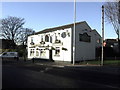
Staff of Life, Swinton
Burtonwood bitter served in this pub. At one time, probably the Staff of Life at the end of many a shift for bus crews from the former LUT bus depot that it once backed onto.
Image: © al partington
Taken: 13 Dec 2007
0.05 miles
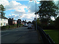
2
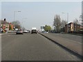
Worsley Road
The A572 Worsley Road near its junction with the A580 East Lancs Road.
Image: © Gerald England
Taken: 24 Sep 2016
0.06 miles
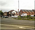
3
East Lancashire Road "Halfords Junction"
The Halfords store has stood at the junction of the A580 (East Lancashire Road) and A572 (Worsley Road) for as long as I can remember and is something of a landmark on the route into Manchester via the East Lancs Road.
Image: © David Dixon
Taken: 30 Aug 2011
0.06 miles
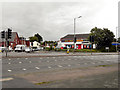
4
Junction on East Lancs Road, Swinton
Image: © Anthony Parkes
Taken: 26 Jun 2010
0.08 miles
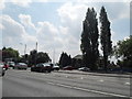
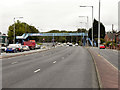
5
A580 approaching Worsley Road junction (A572)
The East Lancashire Road is about to cross its winding predecessor for the final time at its eastern end. Both routes will soon meet the A6 and be subsumed into that route.
Image: © Peter Whatley
Taken: 24 Mar 2011
0.11 miles
6
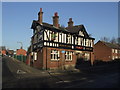
The Park Inn, Swinton
Nothing more needed to draw one inside than the Joseph Holt brewery sign. One of the many Holt establishments in the area.
Image: © al partington
Taken: 13 Dec 2007
0.14 miles

9
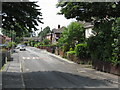
Grasmere Road, Swinton, Looking West
Part of an estate named after charming Lake District locations: presumably not intended to be ironic.
Image: © Peter Whatley
Taken: 1 Jul 2009
0.16 miles
10
Eccles Road junction with the East Lancs Road
Image: © Ian Greig
Taken: 16 Sep 2010
0.16 miles