IMAGES TAKEN NEAR TO
Nassau Drive, MANCHESTER, M27 5BA
Introduction
This page details the photographs taken nearby to Nassau Drive, M27 5BA by members of the Geograph project.
The Geograph project started in 2005 with the aim of publishing, organising and preserving representative images for every square kilometre of Great Britain, Ireland and the Isle of Man.

There are currently over 7.5m images from over14,400 individuals and you can help contribute to the project by visiting https://www.geograph.org.uk
Image Map (Loading...)


Getting Data...Please wait
Leaflet Map data © OpenStreetMap
Images are licensed for reuse under creativecommons.org/licenses/by-sa/2.0
Notes
- Clicking on the map will re-center to the selected point.
- The higher the marker number, the further away the image location is from the centre of the postcode.
Image Listing (6 Images Found)
Images are licensed for reuse under creativecommons.org/licenses/by-sa/2.0
Image
Details
Distance
1
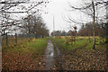
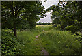
Path near Campbell Road Wood
The streetlamps suggest this path may have been grander than it now is.
Image: © Bill Boaden
Taken: 30 Nov 2016
0.10 miles
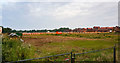
3
Undeveloped land between Swinton and Eccles
I presume this land is designated as green belt. Much of it appears to be owned by United Utilities.
Image: © Bill Boaden
Taken: 30 Nov 2016
0.19 miles
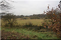
4
Muddy path near Ellesmere Park
Normal conditions for the time of year.
Image: © Bill Boaden
Taken: 30 Nov 2016
0.19 miles
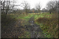
6
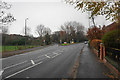
Folly Lane
Dales brow forks off to the left, being a one-way short cut to Worsley Road.
Image: © Bill Boaden
Taken: 30 Nov 2016
0.22 miles