IMAGES TAKEN NEAR TO
Bain Street, MANCHESTER, M27 5AE
Introduction
This page details the photographs taken nearby to Bain Street, M27 5AE by members of the Geograph project.
The Geograph project started in 2005 with the aim of publishing, organising and preserving representative images for every square kilometre of Great Britain, Ireland and the Isle of Man.

There are currently over 7.5m images from over14,400 individuals and you can help contribute to the project by visiting https://www.geograph.org.uk
Image Map
Images are licensed for reuse under creativecommons.org/licenses/by-sa/2.0
Notes
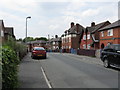
- Clicking on the map will re-center to the selected point.
- The higher the marker number, the further away the image location is from the centre of the postcode.
Image Listing (11 Images Found)
Images are licensed for reuse under creativecommons.org/licenses/by-sa/2.0
Image
Details
Distance
1
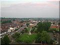
View from Salford Civic Centre Clock Tower
Image: © Anthony Parkes
Taken: 1 May 2000
0.05 miles
2
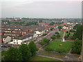
View from the top of Salford Civic Centre
Image: © Anthony Parkes
Taken: 1 May 2000
0.10 miles

4
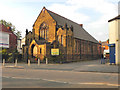
Manchester Road Methodist Church, Swinton
Image: © David Dixon
Taken: 9 Oct 2010
0.21 miles
5
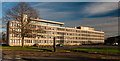
Salford Civic Centre
Salford Civic Centre at Swinton.
Image: © Peter McDermott
Taken: 22 Nov 2014
0.21 miles
6

Salford Civic Centre
The clock tower at Salford Civic Centre in Swinton.
Image: © Peter McDermott
Taken: 22 Nov 2014
0.21 miles
7

Swinton Town Hall/Salford Civic Centre
Swinton and Pendlebury Town Hall on Chorley Road was opened in September 1938. In 1974 the new 'city of Salford' was formed following the reorganisation of local government in England and Wales and Swinton town hall was chosen as the administrative headquarters of the new Metropolitan District's office, and so, on 1 April 1974, it officially became the Salford Civic Centre.
http://www.salford.gov.uk/civiccentre.htm
Image: © David Dixon
Taken: 29 Jan 2010
0.21 miles
8
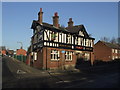
The Park Inn, Swinton
Nothing more needed to draw one inside than the Joseph Holt brewery sign. One of the many Holt establishments in the area.
Image: © al partington
Taken: 13 Dec 2007
0.22 miles
9
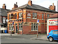
Cricketers Arms, Swinton
The Cricketers Arms public house, on Manchester Road (the A6) at Swinton.
Image: © David Dixon
Taken: 9 Oct 2010
0.23 miles