IMAGES TAKEN NEAR TO
Kingsway, MANCHESTER, M27 4JX
Introduction
This page details the photographs taken nearby to Kingsway, M27 4JX by members of the Geograph project.
The Geograph project started in 2005 with the aim of publishing, organising and preserving representative images for every square kilometre of Great Britain, Ireland and the Isle of Man.

There are currently over 7.5m images from over14,400 individuals and you can help contribute to the project by visiting https://www.geograph.org.uk
Image Map
Images are licensed for reuse under creativecommons.org/licenses/by-sa/2.0
Notes
- Clicking on the map will re-center to the selected point.
- The higher the marker number, the further away the image location is from the centre of the postcode.
Image Listing (16 Images Found)
Images are licensed for reuse under creativecommons.org/licenses/by-sa/2.0
Image
Details
Distance
1
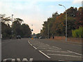
Manchester Road (A6), Pendlebury
Manchester Road, passing the grounds of the former Pendlebury Children's Hospital.
Image: © David Dixon
Taken: 9 Oct 2010
0.11 miles
2
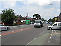
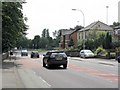
Bolton Road, Pendlebury, Looking North
Image: © Peter Whatley
Taken: 1 Jul 2009
0.18 miles
3
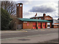
Pendlebury Fire Station
Bolton Road (the A666)
Image: © David Dixon
Taken: 28 Mar 2010
0.21 miles
4
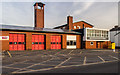
Agecroft Community Fire Station
Agecroft Community Fire Station at Pendlebury.
Image: © Peter McDermott
Taken: 7 Feb 2015
0.21 miles
5
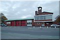
Agecroft fire station
Agecroft fire station, Bolton Road, Pendlebury, Greater Manchester
Image: © Kevin Hale
Taken: 30 Oct 2007
0.21 miles
6
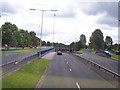
The East Lancs Road underpass at the junction with the A6 and A666
Image: © Raymond Knapman
Taken: 24 Jun 2011
0.21 miles
7
Bolton Road, Pendlebury, Looking South
Image: © Peter Whatley
Taken: 1 Jul 2009
0.21 miles
8
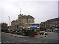
The Children's Hospital
The Royal Manchester Children's Hospital and Hospital Road, Pendlebury. The road and front of the hospital building lie within this square. The bulk of the hospital, however, lies in the one adjacent.
Image: © Keith Williamson
Taken: 5 Sep 2005
0.22 miles
9
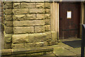
Cut mark with bolt
No85. Bolt in the West face of St. John's New Church tower, Irlams; 3.56ft above flag pavement. From 1GL Abstract on the Bolton to Manchester line
BOLT TWR ST JOHNS CH BOLTON RD NW ANG W FACE
Image: © Ian Charters
Taken: 30 Sep 2012
0.23 miles
10
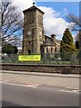
Church of St John (The Evangelist), Pendlebury
Bolton Road.
Image: © David Dixon
Taken: 28 Mar 2010
0.23 miles