IMAGES TAKEN NEAR TO
Osborne Drive, MANCHESTER, M27 4HT
Introduction
This page details the photographs taken nearby to Osborne Drive, M27 4HT by members of the Geograph project.
The Geograph project started in 2005 with the aim of publishing, organising and preserving representative images for every square kilometre of Great Britain, Ireland and the Isle of Man.

There are currently over 7.5m images from over14,400 individuals and you can help contribute to the project by visiting https://www.geograph.org.uk
Image Map
Images are licensed for reuse under creativecommons.org/licenses/by-sa/2.0
Notes
- Clicking on the map will re-center to the selected point.
- The higher the marker number, the further away the image location is from the centre of the postcode.
Image Listing (13 Images Found)
Images are licensed for reuse under creativecommons.org/licenses/by-sa/2.0
Image
Details
Distance
1

Bolton Road passing Rivington Crescent
Rivington Crescent on the left provides a semicircle of lightly wooded green space.
Image: © Bill Boaden
Taken: 18 Sep 2012
0.07 miles
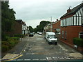
2
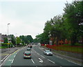
A666 in Pendlebury
A main road between Bolton and Manchester.
Image: © philandju
Taken: 5 Jul 2017
0.08 miles
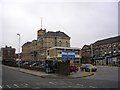
3
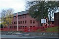
Greater Manchester Fire & Rescue Service Headquarters
Greater Manchester Fire & Rescue Service Headquarters, 146 Bolton Road, Swinton, Manchester, Greater Manchester
Image: © Kevin Hale
Taken: 30 Oct 2007
0.10 miles
4
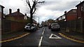
Rivington Avenue, Pendlebury
Viewed from Rivington Crescent.
Image: © Bradley Michael
Taken: 18 Nov 2015
0.10 miles
5
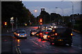
Bolton Road at the top of Agecroft Road
Taken in fading light, which happens increasingly sooner in September.
Image: © Bill Boaden
Taken: 18 Sep 2012
0.14 miles
7
The Children's Hospital
The Royal Manchester Children's Hospital and Hospital Road, Pendlebury. The road and front of the hospital building lie within this square. The bulk of the hospital, however, lies in the one adjacent.
Image: © Keith Williamson
Taken: 5 Sep 2005
0.15 miles
8
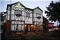
The Henry Boddington
Named after the major influence in the development of Boddington's Brewery, but it could also refer to a landscape artist of the same name. The pub/motel has kept this name through much turbulence for the Boddington's business which has resulted in its disappearance. Boddington's Bitter is still produced in cans at Samlesbury by InBev, one of the global brewing giants.
Image: © Bill Boaden
Taken: 18 Sep 2012
0.18 miles
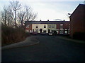
10
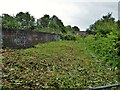
Railway Bridge on Cliveley Road
Some strimming on the left of this view allows sight of the railway towards Salford but alas to the right the flora prevents a view of the former Pendlebury Station site. Cliveley Road is no more than a very narrow path without constant clearance.
Image: © Kevin Waterhouse
Taken: 12 Jul 2023
0.22 miles