IMAGES TAKEN NEAR TO
St. Anns Street, MANCHESTER, M27 0WB
Introduction
This page details the photographs taken nearby to St. Anns Street, M27 0WB by members of the Geograph project.
The Geograph project started in 2005 with the aim of publishing, organising and preserving representative images for every square kilometre of Great Britain, Ireland and the Isle of Man.

There are currently over 7.5m images from over14,400 individuals and you can help contribute to the project by visiting https://www.geograph.org.uk
Image Map
Images are licensed for reuse under creativecommons.org/licenses/by-sa/2.0
Notes
- Clicking on the map will re-center to the selected point.
- The higher the marker number, the further away the image location is from the centre of the postcode.
Image Listing (24 Images Found)
Images are licensed for reuse under creativecommons.org/licenses/by-sa/2.0
Image
Details
Distance
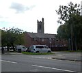
1
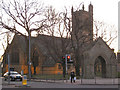
St Peter's Church and lych gate, Swinton
Viewed across the Chorley Road/Partington Lane junction.
http://www.genuki.org.uk/big/eng/LAN/Swinton/StPeter.shtml
Image: © David Dixon
Taken: 29 Jan 2010
0.08 miles
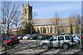
2

St Peter's Church
St Peter's Church, on Partington Lane. Viewed from the library steps.
http://www.genuki.org.uk/big/eng/LAN/Swinton/StPeter.shtml
Image: © David Dixon
Taken: 29 Jan 2010
0.08 miles
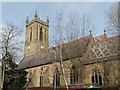
3
Car park by St Peter's Church
This appears to be a church car park but it is also used by the staff of the civic centre.
Image: © Bill Boaden
Taken: 5 Apr 2018
0.11 miles
5
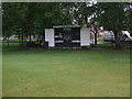
Swinton-Moorside Cricket Club - Scorebox
Swinton-Moorside CC's scorebox. The club run three teams in the Manchester & District Cricket Association and one in the North Manchester Cricket League.
Image: © BatAndBall
Taken: 30 May 2012
0.12 miles
6

St Peter's Church from the top of Salford Civic Centre
Image: © Anthony Parkes
Taken: 1 May 2000
0.12 miles
7
Corner of Union Street and Chorley Road
In the background is the tower of St Peter's Church.
Image: © Gerald England
Taken: 23 Sep 2022
0.14 miles
8
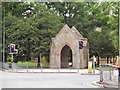
Swinton Lychgate
The ornate gateway to Swinton Churchyard stands on the corner at the main crossroads.
Image: © Roger May
Taken: 16 Aug 2005
0.15 miles
9
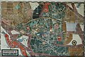
3d town map in display case
I photographed this approximately 1982 in its exact location. This appears to be a left over piece of history from when Swinton and Pendlebury were in Lancashire before being absorbed into Greater Manchester and the expanded city of Salford
Image: © Cliff
Taken: 1 Jan 1982
0.16 miles
10
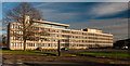
Salford Civic Centre
Salford Civic Centre at Swinton.
Image: © Peter McDermott
Taken: 22 Nov 2014
0.17 miles