IMAGES TAKEN NEAR TO
Godlee Drive, MANCHESTER, M27 0JD
Introduction
This page details the photographs taken nearby to Godlee Drive, M27 0JD by members of the Geograph project.
The Geograph project started in 2005 with the aim of publishing, organising and preserving representative images for every square kilometre of Great Britain, Ireland and the Isle of Man.

There are currently over 7.5m images from over14,400 individuals and you can help contribute to the project by visiting https://www.geograph.org.uk
Image Map
Images are licensed for reuse under creativecommons.org/licenses/by-sa/2.0
Notes
- Clicking on the map will re-center to the selected point.
- The higher the marker number, the further away the image location is from the centre of the postcode.
Image Listing (9 Images Found)
Images are licensed for reuse under creativecommons.org/licenses/by-sa/2.0
Image
Details
Distance
1

The Deans Centre
A youth centre which is part of the Moorside High School.
Image: © Bill Boaden
Taken: 5 Apr 2018
0.06 miles
2
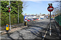
Ellesmere Street
A one way part of the street. Through traffic needs to be restricted where it runs between schools. On the skyline are the towers of St Peter's Church and the Civic Centre in the centre of Swinton.
Image: © Bill Boaden
Taken: 5 Apr 2018
0.09 miles
3
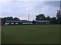
Swinton-Moorside Cricket Club - Pavilion
The old and new pavilions at Swinton-Moorside CC's Moorside Park ground. The newer building to the right of the photo says "Welcome to the Graham Matthews Cricket Ground".
Image: © BatAndBall
Taken: 30 May 2012
0.14 miles
4
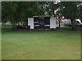
Swinton-Moorside Cricket Club - Scorebox
Swinton-Moorside CC's scorebox. The club run three teams in the Manchester & District Cricket Association and one in the North Manchester Cricket League.
Image: © BatAndBall
Taken: 30 May 2012
0.17 miles
6
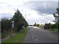
Speed camera on East Lancs Road
Motel and garage on west bound carriageway
Image: © Raymond Knapman
Taken: 24 Jun 2011
0.20 miles
7
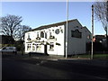
Staff of Life, Swinton
Burtonwood bitter served in this pub. At one time, probably the Staff of Life at the end of many a shift for bus crews from the former LUT bus depot that it once backed onto.
Image: © al partington
Taken: 13 Dec 2007
0.22 miles
8
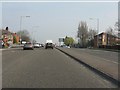
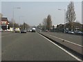
A580 approaching Worsley Road junction (A572)
The East Lancashire Road is about to cross its winding predecessor for the final time at its eastern end. Both routes will soon meet the A6 and be subsumed into that route.
Image: © Peter Whatley
Taken: 24 Mar 2011
0.22 miles
9
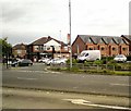
Worsley Road
The A572 Worsley Road near its junction with the A580 East Lancs Road.
Image: © Gerald England
Taken: 24 Sep 2016
0.24 miles