IMAGES TAKEN NEAR TO
Ringlow Park Road, MANCHESTER, M27 0HB
Introduction
This page details the photographs taken nearby to Ringlow Park Road, M27 0HB by members of the Geograph project.
The Geograph project started in 2005 with the aim of publishing, organising and preserving representative images for every square kilometre of Great Britain, Ireland and the Isle of Man.

There are currently over 7.5m images from over14,400 individuals and you can help contribute to the project by visiting https://www.geograph.org.uk
Image Map
Images are licensed for reuse under creativecommons.org/licenses/by-sa/2.0
Notes
- Clicking on the map will re-center to the selected point.
- The higher the marker number, the further away the image location is from the centre of the postcode.
Image Listing (15 Images Found)
Images are licensed for reuse under creativecommons.org/licenses/by-sa/2.0
Image
Details
Distance
1
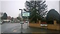
Welcome to Worsley: City of Salford
The boundary sign between Worsley and Swinton, both in the City of Salford district of Greater Manchester, England. This sign is at Ringlow Park Road, taken from within Hazelhurst in Swinton.
Image: © Steven Haslington
Taken: 20 Feb 2016
0.09 miles
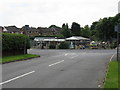
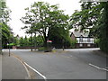
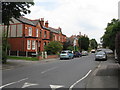
3
Broadoak Park Garden Centre & Surrounding Houses
Image: © Peter Whatley
Taken: 1 Jul 2009
0.13 miles
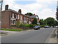
4
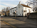
The White Horse
The White Horse public house, 384 Worsley Road, Swinton.
Image: © David Dixon
Taken: 24 Feb 2011
0.14 miles
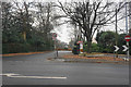
5
Hazelhurst Road Telephone Box
Unusually situated in an island at the end of the road.
Image: © Peter Whatley
Taken: 1 Jul 2009
0.14 miles
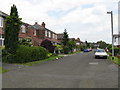
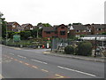
7
Hazelhurst Road
The entrance to the Broad Oak Park and Egerton Park residential areas off Worsley Road.
Image: © Bill Boaden
Taken: 30 Nov 2016
0.17 miles
10
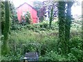
Disused pumping station site, Hazelhurst Road
Image: © Alex McGregor
Taken: 17 Jun 2011
0.18 miles