IMAGES TAKEN NEAR TO
Stable Fold, MANCHESTER, M26 4ST
Introduction
This page details the photographs taken nearby to Stable Fold, M26 4ST by members of the Geograph project.
The Geograph project started in 2005 with the aim of publishing, organising and preserving representative images for every square kilometre of Great Britain, Ireland and the Isle of Man.

There are currently over 7.5m images from over14,400 individuals and you can help contribute to the project by visiting https://www.geograph.org.uk
Image Map
Images are licensed for reuse under creativecommons.org/licenses/by-sa/2.0
Notes
- Clicking on the map will re-center to the selected point.
- The higher the marker number, the further away the image location is from the centre of the postcode.
Image Listing (298 Images Found)
Images are licensed for reuse under creativecommons.org/licenses/by-sa/2.0
Image
Details
Distance
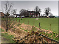
1
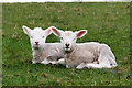
Two Spring Lambs
Clearly not following the government's advice to "social distance" during the Coronavirus outbreak.
Image: © David Dixon
Taken: 28 Mar 2020
0.03 miles
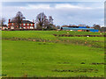
2
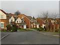
Chestnut Fold
Part of a housing development built during the early 1990s
Image: © David Dixon
Taken: 23 Mar 2012
0.03 miles
3
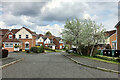
Chestnut Fold
Part of a housing estate constructed in the early 1990s.
Image: © David Dixon
Taken: 2 May 2021
0.04 miles
6
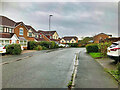
Radcliffe, Shetland Way
Part of a housing estate built in the 1990s.
Image: © David Dixon
Taken: 2 Oct 2021
0.04 miles

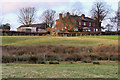
10
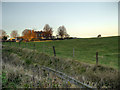
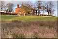
Coney Green Farm
Farmland behind Chestnut Fold.
Image: © David Dixon
Taken: 1 Dec 2012
0.06 miles