IMAGES TAKEN NEAR TO
Starling Close, MANCHESTER, M26 4NA
Introduction
This page details the photographs taken nearby to Starling Close, M26 4NA by members of the Geograph project.
The Geograph project started in 2005 with the aim of publishing, organising and preserving representative images for every square kilometre of Great Britain, Ireland and the Isle of Man.

There are currently over 7.5m images from over14,400 individuals and you can help contribute to the project by visiting https://www.geograph.org.uk
Image Map
Images are licensed for reuse under creativecommons.org/licenses/by-sa/2.0
Notes
- Clicking on the map will re-center to the selected point.
- The higher the marker number, the further away the image location is from the centre of the postcode.
Image Listing (24 Images Found)
Images are licensed for reuse under creativecommons.org/licenses/by-sa/2.0
Image
Details
Distance
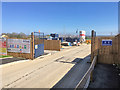
1
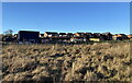
Housing development off Bolton Road
There has been much recent debate about 3500 new homes to be built west of Elton Reservoir. The debate continues but this area north of the old railway line is already being developed.
Image: © Bill Boaden
Taken: 22 Feb 2021
0.11 miles
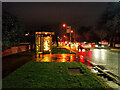
2

Early Christmas Lightshow on Bolton Road
Festive display outside a bungalow on Bolton Road; late November.
Image: © David Dixon
Taken: 26 Nov 2020
0.11 miles
3
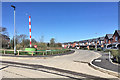
Tudor Grange, Farm Crescent
New housing development at Spen Moor.
Image: © David Dixon
Taken: 20 Apr 2018
0.13 miles
6
Tudor Grange Housing Development Site, Spen Moor
Image: © David Dixon
Taken: 20 Apr 2018
0.14 miles
8
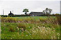
Higher Spen Moor Farm
Viewed from the line of the former railway track between Bury and Bolton.
Image: © Bill Boaden
Taken: 19 May 2012
0.15 miles
9
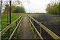
Diverted path past Lower Spen Moor Farm
There is no wandering off this path.
Image: © Bill Boaden
Taken: 19 May 2012
0.16 miles
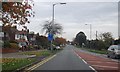
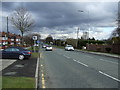
10
Cycle Lane sign on the A58
Watling Street on left
Image: © Raymond Knapman
Taken: 26 Jul 2012
0.17 miles