IMAGES TAKEN NEAR TO
Davenport Avenue, MANCHESTER, M26 4HS
Introduction
This page details the photographs taken nearby to Davenport Avenue, M26 4HS by members of the Geograph project.
The Geograph project started in 2005 with the aim of publishing, organising and preserving representative images for every square kilometre of Great Britain, Ireland and the Isle of Man.

There are currently over 7.5m images from over14,400 individuals and you can help contribute to the project by visiting https://www.geograph.org.uk
Image Map
Images are licensed for reuse under creativecommons.org/licenses/by-sa/2.0
Notes
- Clicking on the map will re-center to the selected point.
- The higher the marker number, the further away the image location is from the centre of the postcode.
Image Listing (67 Images Found)
Images are licensed for reuse under creativecommons.org/licenses/by-sa/2.0
Image
Details
Distance
1
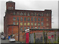
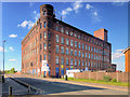
Constellation Mill
Situated at the corner of Hardman Street and Ainsworth Road, in the Black Lane Area of Radcliffe, This former cotton mill was originally called Black Lane Mill. Now named Constellation Mill it has, like other mills in the area, been converted into smaller units.
I'm not sure what has happened to the Renault Megane in the foreground, but it looks to be in poor shape.
Image: © David Dixon
Taken: 6 Jan 2012
0.04 miles
2
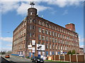
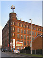
Constellation Mill
This former cotton mill on Ainsworth Road used to be owned by the Black Lane Mills Company Ltd cotton spinners.
Today the name has changed to Constellation Mill and it has been divided up into small separate business units.
Image: © Paul Anderson
Taken: 11 Apr 2007
0.04 miles
3
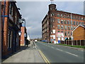
The New Inn & Constelation Mill Ainsworth Road, Radcliffe.
Constelation Mill also known as Black Lane Mill in the area of St Andrews in Radcliffe.
Image: © Andrew Forrest
Taken: 8 Feb 2007
0.05 miles
4
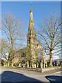
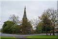
The Parish Church of St Andrew, Radcliffe
St Andrew’s is a parish church in the northern part of Radcliffe, at the corner of St Andrew's Road and St Andrew's View. Consecrated in 1877, it is a Grade II listed building (Historic England List entry Number: 1067218 https://historicengland.org.uk/listing/the-list/list-entry/1067218 ).
http://www.standrewsradcliffe.org.uk/ for the church website
Image: © David Dixon
Taken: 20 Apr 2018
0.05 miles
5
Constellation Mill
Situated at the corner of Hardman Street and Ainsworth Road, in the Black Lane Area of Radcliffe, This former cotton mill was originally called Black Lane Mill. Now named Constellation Mill it has, like other mills in the area, been converted into smaller units.
Image: © David Dixon
Taken: 14 May 2020
0.05 miles
6
Constellation Mill, Radcliffe
Former cotton mill on Ainsworth Road. Like others in the area, it is now converted into smaller units.
Image: © David Dixon
Taken: 28 Jan 2010
0.05 miles
7
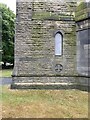
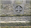
Location of OS Cut Mark - Radcliffe, St Andrews Church
Image: © thejackrustles
Taken: 21 Jul 2022
0.06 miles
9
Location of OS Cut Mark - Radcliffe, St Andrews Church
Image: © thejackrustles
Taken: 21 Jul 2022
0.06 miles
10
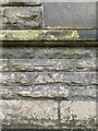
OS Cut Mark - Radcliffe, St Andrews Church
https://www.bench-marks.org.uk/bm74856
Image: © thejackrustles
Taken: 21 Jul 2022
0.06 miles