IMAGES TAKEN NEAR TO
Ainsworth Road, MANCHESTER, M26 4ED
Introduction
This page details the photographs taken nearby to Ainsworth Road, M26 4ED by members of the Geograph project.
The Geograph project started in 2005 with the aim of publishing, organising and preserving representative images for every square kilometre of Great Britain, Ireland and the Isle of Man.

There are currently over 7.5m images from over14,400 individuals and you can help contribute to the project by visiting https://www.geograph.org.uk
Image Map
Images are licensed for reuse under creativecommons.org/licenses/by-sa/2.0
Notes
- Clicking on the map will re-center to the selected point.
- The higher the marker number, the further away the image location is from the centre of the postcode.
Image Listing (82 Images Found)
Images are licensed for reuse under creativecommons.org/licenses/by-sa/2.0
Image
Details
Distance
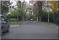
4
Queuing Arrangements on Cemetery Road
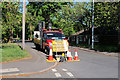
On 23 March, During the 2020 coronavirus pandemic https://en.wikipedia.org/wiki/2020_coronavirus_pandemic_in_the_United_Kingdom , the UK government imposed a lockdown on the whole population, banning all "non-essential" travel and contact with people outside one's home. All restaurants, pubs, clubs and indoor sport and leisure facilities were ordered to close. Initially, all of the recycling centres in the Bury MBC area were closed (many cited this as a cause of the increased amount of fly tipping around the borough).
In May the council announced a limited re-opening of the Household waste recycling centres, beginning with the Radcliffe HWRC on Cemetery Road which opened from Saturday 16 May, with restricted opening hours. Some of the restrictions are listed on notice attached to the gate Image The centre could only be visited by private car (no pedestrian access was allowed) and only one vehicle was allowed into the facility at any one time. This meant that vehicles had to queue on Cemetery Road.
Image: © David Dixon
Taken: 20 May 2020
0.03 miles
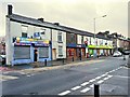
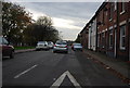
6
Alma Street, Radcliffe
Early twentieth century houses on Alma Street.
Image: © David Dixon
Taken: 30 Jul 2021
0.03 miles
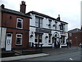
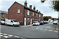
8
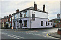
The Victoria Hotel, Ainsworth Road
Public house on Ainsworth Road at the corner with Lowe Street.
Image: © David Dixon
Taken: 13 Oct 2020
0.05 miles
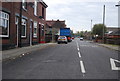
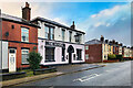
9
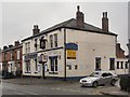
The Victoria
Public house on Ainsworth Road at the corner with Lowe Street.
Image: © David Dixon
Taken: 7 Feb 2010
0.05 miles