IMAGES TAKEN NEAR TO
Cooperative Street, MANCHESTER, M26 4DX
Introduction
This page details the photographs taken nearby to Cooperative Street, M26 4DX by members of the Geograph project.
The Geograph project started in 2005 with the aim of publishing, organising and preserving representative images for every square kilometre of Great Britain, Ireland and the Isle of Man.

There are currently over 7.5m images from over14,400 individuals and you can help contribute to the project by visiting https://www.geograph.org.uk
Image Map
Images are licensed for reuse under creativecommons.org/licenses/by-sa/2.0
Notes
- Clicking on the map will re-center to the selected point.
- The higher the marker number, the further away the image location is from the centre of the postcode.
Image Listing (327 Images Found)
Images are licensed for reuse under creativecommons.org/licenses/by-sa/2.0
Image
Details
Distance
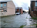
2
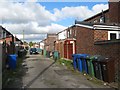
Backs, Knowles Street
Backs are sometimes a more illuminating subject than their associated streets. Once again, the issue here is dustbins. In olden times, when one dustbin sufficed for the weekly output of houses, it was zealously guarded in the back-yard. Now, with up to four bins per household there simply isn't room inside to look after them all. At least the backs contain the menace, unlike other less-favoured areas with only 'fronts'.
Image: © Jonathan Wilkins
Taken: 23 Oct 2016
0.01 miles
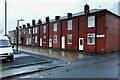
4
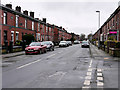
Knowles Street
Terraced housing on Knowles Street.
Image: © David Dixon
Taken: 17 Feb 2016
0.03 miles
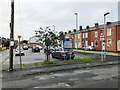
5
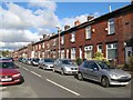
Knowles Street
Terraced houses are seen in Knowles Street close to its junction with Robertson Street.
Image: © Jonathan Wilkins
Taken: 23 Oct 2016
0.03 miles
6
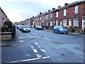
Radcliffe, Knowles Street
Terraced houses on Knowles Street.
Image: © David Dixon
Taken: 25 Jan 2014
0.03 miles
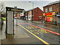
8
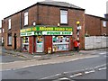
Pound Shop
Former post office at the bottom of Ainsworth Road.
Image: © David Dixon
Taken: 7 Feb 2010
0.04 miles
9
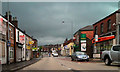
Ainsworth Road (B6292)
Looking northwards along Ainsworth Road, from Water Street.
Image: © David Dixon
Taken: 20 Jul 2010
0.04 miles