IMAGES TAKEN NEAR TO
Knowles Street, MANCHESTER, M26 4DR
Introduction
This page details the photographs taken nearby to Knowles Street, M26 4DR by members of the Geograph project.
The Geograph project started in 2005 with the aim of publishing, organising and preserving representative images for every square kilometre of Great Britain, Ireland and the Isle of Man.

There are currently over 7.5m images from over14,400 individuals and you can help contribute to the project by visiting https://www.geograph.org.uk
Image Map
Images are licensed for reuse under creativecommons.org/licenses/by-sa/2.0
Notes
- Clicking on the map will re-center to the selected point.
- The higher the marker number, the further away the image location is from the centre of the postcode.
Image Listing (188 Images Found)
Images are licensed for reuse under creativecommons.org/licenses/by-sa/2.0
Image
Details
Distance
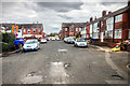
1
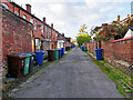
Back Alley between Knowles Street and Lowton Street
Image: © David Dixon
Taken: 20 Oct 2020
0.02 miles
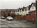
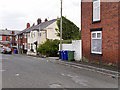
2
Knowles Street
Looking down Knowles Street, from Belgrave Street towards Water Street
Image: © David Dixon
Taken: 1 Jan 2011
0.02 miles
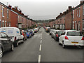
4
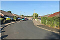
Radcliffe, Lowton Street
Bungalows built in the mid-1970s.
Image: © David Dixon
Taken: 26 Jul 2021
0.04 miles
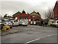
7
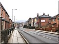
Ainsworth Road
Looking downhill, towards Bolton Road and Water Street.
Image: © David Dixon
Taken: 7 Feb 2010
0.08 miles
9
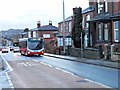
Bus on Ainsworth Road
Rossendale Transport's Volvo B7RLE, PO59 MLK, climbs Ainsworth Road in Radcliffe, on route 486 towards Bury.
Image: © David Dixon
Taken: 25 Jan 2014
0.08 miles