IMAGES TAKEN NEAR TO
Grosvenor Street, MANCHESTER, M26 4BQ
Introduction
This page details the photographs taken nearby to Grosvenor Street, M26 4BQ by members of the Geograph project.
The Geograph project started in 2005 with the aim of publishing, organising and preserving representative images for every square kilometre of Great Britain, Ireland and the Isle of Man.

There are currently over 7.5m images from over14,400 individuals and you can help contribute to the project by visiting https://www.geograph.org.uk
Image Map
Images are licensed for reuse under creativecommons.org/licenses/by-sa/2.0
Notes
- Clicking on the map will re-center to the selected point.
- The higher the marker number, the further away the image location is from the centre of the postcode.
Image Listing (179 Images Found)
Images are licensed for reuse under creativecommons.org/licenses/by-sa/2.0
Image
Details
Distance
1
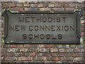
Methodist New Connexion School (plaque)
Stone plaque above the first floor windows of the former sunday school building on Smyrna Street (Image]).
Image: © David Dixon
Taken: 1 Jan 2012
0.03 miles
2
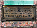
Methodist New Connexion School (Memorial Plaque)
The stone memorial plaque beneath the ground floor window of the former sunday school building on Smyrna Street (Image]).
Image: © David Dixon
Taken: 1 Jan 2012
0.04 miles
3
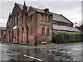
Woodmod (Former Sunday School)
The premises of Woodmod Ltd, in Smyrna Street, previously housed the New Connexions Methodist Church Sunday School. A memorial stone below the groundfloor window suggests that the building dates from 1883.
See Image] and Image] for building detail.
Image: © David Dixon
Taken: 1 Jan 2012
0.04 miles
4
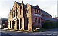
Old School
Methodist New Connexion School.
Memorial stone laid by William Agnew MP
25th August 1883
Image: © Pete Spooner
Taken: 12 Nov 2011
0.05 miles
5
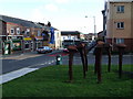
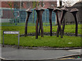
Rusty Nails on Ainsworth Road
Another one of the sculptures on the Irwell Sculpture Trail. Ainsworth Road is also known locally as Black Lane .
Image: © Andrew Forrest
Taken: 6 Feb 2007
0.06 miles
7
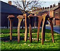
Nailing home, sculpture
See Irwell sculpture trail,
http://en.wikipedia.org/wiki/Irwell_Sculpture_Trail#Radcliffe
Image: © Pete Spooner
Taken: 12 Nov 2011
0.08 miles
8
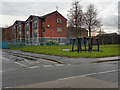
Smyrna Street
The corner of Smyrna Street and Ainsworth Road. In front of the social housing development is the sculpture Image, the work of local artist Jack Wright http://en.wikipedia.org/wiki/Irwell_Sculpture_Trail#Nailing_Home.
Image: © David Dixon
Taken: 1 Jan 2012
0.09 miles
9
Nailing Home
Standing at the corner of Smyrna Street and Ainsworth Road, "Nailing Home" is the work of local sculptor, Jack Wright. It is part of the Irwell Sculpture Trail (http://en.wikipedia.org/wiki/Irwell_Sculpture_Trail#Nailing_Home )
The work was commissioned jointly by the Irwell Sculpture Trail and Irwell Valley Housing Association. It takes the form of enlarged frost nails. The stems of the nails are meant to suggest growth with the heads reminiscent of a house roof, thus representing The Irwell Valley Housing Association who have developed social housing on this site (Image]).
Image: © David Dixon
Taken: 1 Jan 2012
0.09 miles