IMAGES TAKEN NEAR TO
Ebury Street, MANCHESTER, M26 4BL
Introduction
This page details the photographs taken nearby to Ebury Street, M26 4BL by members of the Geograph project.
The Geograph project started in 2005 with the aim of publishing, organising and preserving representative images for every square kilometre of Great Britain, Ireland and the Isle of Man.

There are currently over 7.5m images from over14,400 individuals and you can help contribute to the project by visiting https://www.geograph.org.uk
Image Map
Images are licensed for reuse under creativecommons.org/licenses/by-sa/2.0
Notes
- Clicking on the map will re-center to the selected point.
- The higher the marker number, the further away the image location is from the centre of the postcode.
Image Listing (175 Images Found)
Images are licensed for reuse under creativecommons.org/licenses/by-sa/2.0
Image
Details
Distance
2
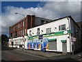
Post-industrial, post-retail
A former mill building now houses the Dynamic Gym health & fitness centre, while Barlows Corner Shop seems to have given up entirely.
Image: © Jonathan Wilkins
Taken: 23 Oct 2016
0.05 miles
3
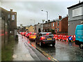
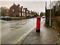
Traffic on Water Street
A traffic queue on Water Street on a very wet day.
Image: © David Dixon
Taken: 10 Mar 2021
0.06 miles
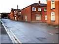
4
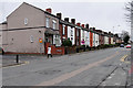
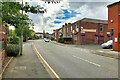
Terraced Housing on Bolton Road
The A665, just to the north of the town centre.
Image: © David Dixon
Taken: 29 Mar 2016
0.06 miles
6
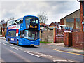
524 on Water Street
Diamond Bus North West Wright Streetdeck 40760 (MX20 KYS) travelling along Water Street (A665), approaching Radcliffe town centre on the 524 service between Bolton and Bury.
Image: © David Dixon
Taken: 12 Mar 2021
0.06 miles
7
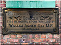
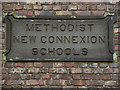
Methodist New Connexion School (Memorial Plaque)
The stone memorial plaque beneath the ground floor window of the former sunday school building on Smyrna Street (Image]).
Image: © David Dixon
Taken: 1 Jan 2012
0.06 miles
9
Methodist New Connexion School (plaque)
Stone plaque above the first floor windows of the former sunday school building on Smyrna Street (Image]).
Image: © David Dixon
Taken: 1 Jan 2012
0.07 miles
10
Bolton Road, WHB Construction Ltd
The former Turf Hotel (Image]) closed in 2012 and was converted into office premises.
Image: © David Dixon
Taken: 12 Oct 2020
0.07 miles