IMAGES TAKEN NEAR TO
Blackburn Street, MANCHESTER, M26 3WQ
Introduction
This page details the photographs taken nearby to Blackburn Street, M26 3WQ by members of the Geograph project.
The Geograph project started in 2005 with the aim of publishing, organising and preserving representative images for every square kilometre of Great Britain, Ireland and the Isle of Man.

There are currently over 7.5m images from over14,400 individuals and you can help contribute to the project by visiting https://www.geograph.org.uk
Image Map
Images are licensed for reuse under creativecommons.org/licenses/by-sa/2.0
Notes
- Clicking on the map will re-center to the selected point.
- The higher the marker number, the further away the image location is from the centre of the postcode.
Image Listing (483 Images Found)
Images are licensed for reuse under creativecommons.org/licenses/by-sa/2.0
Image
Details
Distance
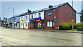
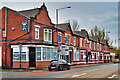
2
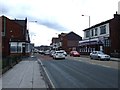
Blackburn Street
Large terrace properties, mostly used as offices. Looking at old maps, this area seems to have been developed between 1890 and 1910.
Image: © David Dixon
Taken: 10 Jan 2021
0.01 miles

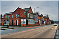
5

Istanbul Grill, Blackburn Street
Despite the restrictions imposed to limit the spread of the coronavirus pandemic, ongoing work to refurbish this former Indian restaurant has continued and now appears to be at an advanced stage. Given that all restaurants are currently closed because of the restrictions, the "opening soon" flashes on the banner seem to be a little over-optimistic.
Image: © David Dixon
Taken: 10 May 2020
0.02 miles
6
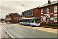
Diamond Bus on Blackburn Street
Diamond Bus North West Wright Eclipse Urban, Volvo B7RLE, 66914 (MX55 FGE) passing through Radcliffe on route 524 between Bury and Bolton.
Image: © David Dixon
Taken: 11 Jan 2021
0.02 miles
9
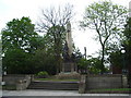
Radcliffe War Memorial
Radcliffe Cenotaph, seen shortly after the Service of Remembrance which, as is traditional, was held on the Sunday nearest to Armistice Day http://en.wikipedia.org/wiki/Remembrance_Sunday. It was built in 1922 as a memorial to those killed in “the war to end all wars”. Like other such memorials, it now honours casualties from all conflicts since the First World War.
The memorial is a grade II* listed structure.
Image: © David Dixon
Taken: 13 Nov 2011
0.03 miles
10
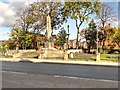
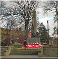
War Memorial and Memorial Garden, Blackburn Street
Radcliffe Cenotaph stands in a small memorial garden, opposite the former town hall. First unveiled on 26 November 1922, it takes the form of an obelisk which rises to 35 feet above street level. The obelisk is mounted on a plinth set on a square raised terrace with surrounding walls and steps to Blackburn Street. The four main faces of the pedestal have large square bronze panels containing in relief 642 names of the fallen of 1914-1918; the narrow re-entrant sides have matching rectangular panels of names headed 1939-1945 (see Roll of Honour http://www.roll-of-honour.com/Lancashire/Radcliffe.html for a list).
The front of the obelisk has a sword with a laurel wreath round the handle; its base is surrounded by statuary on three sides. The statues, three large winged female figures are emblematic of Liberty, Victory and Peace. Victory, standing in the centre, holds Liberty by one hand and in the other holds up the laurel emblem of conquest; Liberty to the left breaks free, raising a flaming torch; Peace, to the right, reclines on one leg, with roses of remembrance in her lap, listening to the message of a dove perched on her shoulder.
The memorial is designated as a Grade II* Listed Building by English Heritage (English Heritage ID:210777 http://www.britishlistedbuildings.co.uk/en-210777-radcliffe-cenotaph- British Listed Buildings)
Image: © David Dixon
Taken: 10 Nov 2013
0.03 miles