IMAGES TAKEN NEAR TO
Edgemoor Close, MANCHESTER, M26 3NQ
Introduction
This page details the photographs taken nearby to Edgemoor Close, M26 3NQ by members of the Geograph project.
The Geograph project started in 2005 with the aim of publishing, organising and preserving representative images for every square kilometre of Great Britain, Ireland and the Isle of Man.

There are currently over 7.5m images from over14,400 individuals and you can help contribute to the project by visiting https://www.geograph.org.uk
Image Map
Images are licensed for reuse under creativecommons.org/licenses/by-sa/2.0
Notes
- Clicking on the map will re-center to the selected point.
- The higher the marker number, the further away the image location is from the centre of the postcode.
Image Listing (17 Images Found)
Images are licensed for reuse under creativecommons.org/licenses/by-sa/2.0
Image
Details
Distance
1
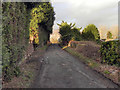
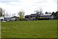
Chatsworth Road
The lane leading to Moss Shaw Farm, from Moss Shaw Way.
Image: © David Dixon
Taken: 2 Jan 2012
0.08 miles
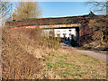
2
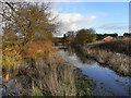
The Bridge at Moss Shaw Farm
The bridge over the disused Liverpool and Bury (later Lancashire and Yorkshire) Railway, approaching Moss Shaw Farm.
Image: © David Dixon
Taken: 2 Jan 2012
0.09 miles
3
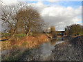
Moss Shaw Bridge
A view of the bridge which takes Chatsworth Road over the route of the former Liverpool and Bury (later Lancashire and Yorkshire) Railway between Bradley Fold and Black Lane, near to Moss Shaw Farm.
The Liverpool and Bury Railway was formed in 1845. In 1847, it was incorporated into the Lancashire and Yorkshire Railway and from 1922, until nationalisation, was part of the London, Midland and Scottish Railway.
The line between Bolton and Bury was closed in 1970 and part of the route, as here, is now a footpath although it has been built over in other places (https://bit.ly/3brUqCJ - Heywood Advertiser, archived November 2012).
Image: © David Dixon
Taken: 2 Mar 2021
0.09 miles
4
Course of Former Railway
Looking in the direction of Bradley Fold, from the bridge at Moss Shaw Farm.
Following recent heavy rainfall, the footpath along the course of the former Liverpool and Bury (later Lancashire and Yorkshire) Railway has become impassable at this point .
The Liverpool and Bury Railway was formed in 1845. In 1847, it was incorporated into the Lancashire and Yorkshire Railway and from 1922, until nationalisation, was part of the London, Midland and Scottish Railway.
The line between Bolton and Bury was closed in 1970 and part of the route, as here, is now a footpath although it has been built over in other places (http://menmedia.co.uk/heywoodadvertiser/news/s/390183_rail_decision_spells_gloom_for_lines_future - Heywood Advertiser).
http://www.lyrs.org.uk/the_railway/ - The Lancashire and Yorkshire Railway Society
http://en.wikipedia.org/wiki/Lancashire_and_Yorkshire_Railway - L&YR article on Wikipedia
Image: © David Dixon
Taken: 2 Jan 2012
0.09 miles
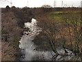
5
Flooding on Disused Railway at Moss Shaw
Approaching the bridge at Moss Shaw Farm, the footpath along the course of the former Liverpool and Bury (later Lancashire and Yorkshire) Railway has become impassable following recent heavy rainfall.
The Liverpool and Bury Railway was formed in 1845. In 1847, it was incorporated into the Lancashire and Yorkshire Railway and from 1922, until nationalisation, was part of the London, Midland and Scottish Railway.
The line between Bolton and Bury was closed in 1970 and part of the route, as here, is now a footpath although it has been built over in other places (http://menmedia.co.uk/heywoodadvertiser/news/s/390183_rail_decision_spells_gloom_for_lines_future - Heywood Advertiser).
http://www.lyrs.org.uk/the_railway/ - The Lancashire and Yorkshire Railway Society
http://en.wikipedia.org/wiki/Lancashire_and_Yorkshire_Railway - L&YR article on Wikipedia
Image: © David Dixon
Taken: 2 Jan 2012
0.11 miles
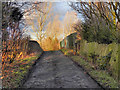
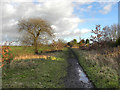
7
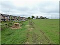
Route of former railway
A footpath on the former Bury to Bolton line approaching Moss Shaw Farm. Beyond the farm is an overbridge which affirms this is a rail route because this field shows no trace of a railway.
Image: © Kevin Waterhouse
Taken: 28 Apr 2023
0.13 miles
8
Disused Railway (flooded)
Approaching the bridge at Moss Shaw Farm, the footpath along the course of the former Liverpool and Bury (later Lancashire and Yorkshire) Railway has become impassable following recent heavy rainfall.
The Liverpool and Bury Railway was formed in 1845. In 1847, it was incorporated into the Lancashire and Yorkshire Railway and from 1922, until nationalisation, was part of the London, Midland and Scottish Railway.
The line between Bolton and Bury was closed in 1970 and part of the route, as here, is now a footpath although it has been built over in other places (http://menmedia.co.uk/heywoodadvertiser/news/s/390183_rail_decision_spells_gloom_for_lines_future - Heywood Advertiser).
http://www.lyrs.org.uk/the_railway/ - The Lancashire and Yorkshire Railway Society
http://en.wikipedia.org/wiki/Lancashire_and_Yorkshire_Railway - L&YR article on Wikipedia
Image: © David Dixon
Taken: 2 Jan 2012
0.14 miles
9
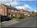
Semi-detached houses, Northlands
Well-established and sought-after houses to the north of Radcliffe.
Image: © Jonathan Wilkins
Taken: 23 Oct 2016
0.15 miles
10
Disused Railway, Moss Shaw
Looking along the route of the former Liverpool and Bury (later Lancashire and Yorkshire) Railway. This view is looking in the direction of Radcliffe (Ainsworth Road and Black Lane). Just ahead, the rooflines of some of the houses on the Moss Shaw estate can be made out above the hedge on the right hand side.
The Liverpool and Bury Railway was formed in 1845. In 1847, it was incorporated into the Lancashire and Yorkshire Railway and from 1922, until nationalisation, was part of the London, Midland and Scottish Railway.
The line between Bolton and Bury was closed in 1970 and part of the route, as here, is now a footpath although it has been built over in other places (http://menmedia.co.uk/heywoodadvertiser/news/s/390183_rail_decision_spells_gloom_for_lines_future - Heywood Advertiser).
http://www.lyrs.org.uk/the_railway/ - The Lancashire and Yorkshire Railway Society
http://en.wikipedia.org/wiki/Lancashire_and_Yorkshire_Railway - L&YR article on Wikipedia
Image: © David Dixon
Taken: 2 Jan 2012
0.18 miles