IMAGES TAKEN NEAR TO
Victoria Street, MANCHESTER, M26 3AY
Introduction
This page details the photographs taken nearby to Victoria Street, M26 3AY by members of the Geograph project.
The Geograph project started in 2005 with the aim of publishing, organising and preserving representative images for every square kilometre of Great Britain, Ireland and the Isle of Man.

There are currently over 7.5m images from over14,400 individuals and you can help contribute to the project by visiting https://www.geograph.org.uk
Image Map
Images are licensed for reuse under creativecommons.org/licenses/by-sa/2.0
Notes
- Clicking on the map will re-center to the selected point.
- The higher the marker number, the further away the image location is from the centre of the postcode.
Image Listing (399 Images Found)
Images are licensed for reuse under creativecommons.org/licenses/by-sa/2.0
Image
Details
Distance
3
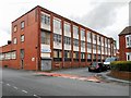
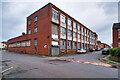
Factory on Wolsey Street
Factory at the corner of Wolsey Street and School Street.
Image: © David Dixon
Taken: 22 Feb 2014
0.07 miles
5
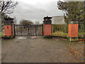
Radcliffe High School Gates
These gates, at the Abden Street Entrance, are all that remains of the former Radcliffe High School which used to stand on the site.
Radcliffe County Secondary School (later to become Radcliffe High School) was founded in 1933 on the former Peel Park Ground near School Street. In 2004, the school merged with the nearby Coney Green Technology College to form the Radcliffe Riverside. The site continued to operate as "The West Campus" until it was closed in the summer of 2010, and it is that name which still stands next to the gate. Demolition of the buildings soon followed the closure, ready for construction of the new special school (Image]) at the School Street end of the site.
Image: © David Dixon
Taken: 24 Dec 2011
0.07 miles
10
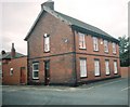
Former Quakers, Lord Street
This is the former Quakers meeting house in Lord Street, Radcliffe. After the Quakers left it became the Salvation Army hall, and is now in residential use.
Image: © Rob K Brettle
Taken: Unknown
0.08 miles