IMAGES TAKEN NEAR TO
Coomassie Street, MANCHESTER, M26 3AU
Introduction
This page details the photographs taken nearby to Coomassie Street, M26 3AU by members of the Geograph project.
The Geograph project started in 2005 with the aim of publishing, organising and preserving representative images for every square kilometre of Great Britain, Ireland and the Isle of Man.

There are currently over 7.5m images from over14,400 individuals and you can help contribute to the project by visiting https://www.geograph.org.uk
Image Map
Images are licensed for reuse under creativecommons.org/licenses/by-sa/2.0
Notes
- Clicking on the map will re-center to the selected point.
- The higher the marker number, the further away the image location is from the centre of the postcode.
Image Listing (420 Images Found)
Images are licensed for reuse under creativecommons.org/licenses/by-sa/2.0
Image
Details
Distance
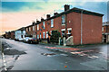
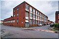
2
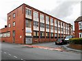
Factory on Wolsey Street
Factory at the corner of Wolsey Street and School Street.
Image: © David Dixon
Taken: 22 Feb 2014
0.06 miles
3

Abden Street Park
Play area not far from the centre of the town.
Image: © David Dixon
Taken: 11 Dec 2020
0.06 miles
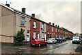
10
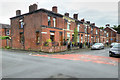
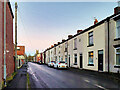
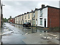
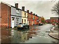
Radcliffe, Victoria Street
Terraced housing close to the town centre.
Image: © David Dixon
Taken: 10 Jun 2016
0.09 miles