IMAGES TAKEN NEAR TO
Orkney Close, MANCHESTER, M26 2WR
Introduction
This page details the photographs taken nearby to Orkney Close, M26 2WR by members of the Geograph project.
The Geograph project started in 2005 with the aim of publishing, organising and preserving representative images for every square kilometre of Great Britain, Ireland and the Isle of Man.

There are currently over 7.5m images from over14,400 individuals and you can help contribute to the project by visiting https://www.geograph.org.uk
Image Map
Images are licensed for reuse under creativecommons.org/licenses/by-sa/2.0
Notes
- Clicking on the map will re-center to the selected point.
- The higher the marker number, the further away the image location is from the centre of the postcode.
Image Listing (304 Images Found)
Images are licensed for reuse under creativecommons.org/licenses/by-sa/2.0
Image
Details
Distance
2
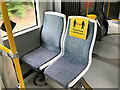
Social Distancing Notice on Metrolink Tram
One of several notices attached to the seats in the Metrolink tram. Perhaps significantly, the "keep 2 metres apart" message has been replaced with the much vaguer "keep a safe distance".
Image: © David Dixon
Taken: 13 Jun 2020
0.03 miles
3
Route of Former Railway at Radcliffe North Junction
Most of the sleepers have disappeared, but the some track remains from the former railway line from Radcliffe North Junction towards Black Lane and Bradley Folds which can be seen on the 1940s OS map. As can be seen in the photograph, the track is now completely overgrown with trees.
Image: © David Dixon
Taken: 29 Apr 2018
0.04 miles
4
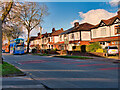
Metrolink Replacement Bus on Bury Road
Diamond Buses Wright Streetdeck 40705 (SO19 MWA) operating the Metrolink replacement service between Bury and Whitefield via Radcliffe.
Image: © David Dixon
Taken: 26 Mar 2021
0.04 miles
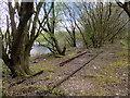
5
Overgrown Railway, Radcliffe North Junction
Most of the sleepers have disappeared, but some track remains from the former railway line from Radcliffe North Junction towards Black Lane and Bradley Fold which can be seen on the 1965 OS map https://www.old-maps.co.uk/#/Map/378841/407813/10/101325 . As can be seen in the photograph, the track is now completely overgrown with trees.
Image: © David Dixon
Taken: 1 Mar 2021
0.04 miles
6
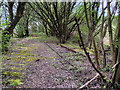
Overgrown Railway, Radcliffe North Junction
Most of the sleepers have disappeared, but the some track remains from the former railway line from Radcliffe North Junction towards Black Lane and Bradley Folds which can be seen on the 1940s OS map. As can be seen in the photograph, the track is now completely overgrown with trees.
Image: © David Dixon
Taken: 29 Apr 2018
0.04 miles
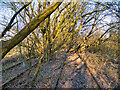
7
Remains of Railway, Radcliffe North Junction
Most of the sleepers have disappeared, but some track remains from the former railway line from Radcliffe North Junction towards Black Lane and Bradley Fold which can be seen on the 1965 OS map https://www.old-maps.co.uk/#/Map/378841/407813/10/101325 . As can be seen in the photograph, the track is now completely overgrown with trees.
Image: © David Dixon
Taken: 1 Mar 2021
0.05 miles