IMAGES TAKEN NEAR TO
Haworth Street, MANCHESTER, M26 2ST
Introduction
This page details the photographs taken nearby to Haworth Street, M26 2ST by members of the Geograph project.
The Geograph project started in 2005 with the aim of publishing, organising and preserving representative images for every square kilometre of Great Britain, Ireland and the Isle of Man.

There are currently over 7.5m images from over14,400 individuals and you can help contribute to the project by visiting https://www.geograph.org.uk
Image Map
Images are licensed for reuse under creativecommons.org/licenses/by-sa/2.0
Notes
- Clicking on the map will re-center to the selected point.
- The higher the marker number, the further away the image location is from the centre of the postcode.
Image Listing (555 Images Found)
Images are licensed for reuse under creativecommons.org/licenses/by-sa/2.0
Image
Details
Distance
1
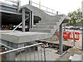
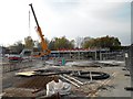
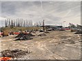
Expansion to Radcliffe's Park and Ride Car Park
Image: © David Dixon
Taken: 30 Apr 2014
0.03 miles
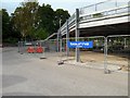
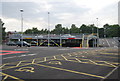
3
Radcliffe Metrolink Park and Ride Construction
Image: © David Dixon
Taken: 30 Apr 2014
0.03 miles
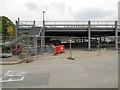
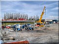
5
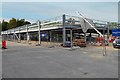
Car Park Construction at Radcliffe Metrolink Station - April 2014
The steel frame for the upper storey has now been erected.
Image: © David Dixon
Taken: 16 Apr 2014
0.04 miles
7
Radcliffe Park and Ride Construction - April 2014
The steel framework to support the car park's upper storey has now been erected.
Image: © David Dixon
Taken: 16 Apr 2014
0.04 miles
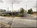
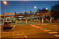
9
Construction Work, Metrolink Park and Ride
Image: © David Dixon
Taken: 19 Mar 2014
0.04 miles
10
Construction of New Park and Ride at Radcliffe (May 2014)
Image: © David Dixon
Taken: 16 May 2014
0.04 miles