IMAGES TAKEN NEAR TO
Heap Street, MANCHESTER, M26 2SS
Introduction
This page details the photographs taken nearby to Heap Street, M26 2SS by members of the Geograph project.
The Geograph project started in 2005 with the aim of publishing, organising and preserving representative images for every square kilometre of Great Britain, Ireland and the Isle of Man.

There are currently over 7.5m images from over14,400 individuals and you can help contribute to the project by visiting https://www.geograph.org.uk
Image Map
Images are licensed for reuse under creativecommons.org/licenses/by-sa/2.0
Notes
- Clicking on the map will re-center to the selected point.
- The higher the marker number, the further away the image location is from the centre of the postcode.
Image Listing (654 Images Found)
Images are licensed for reuse under creativecommons.org/licenses/by-sa/2.0
Image
Details
Distance
1
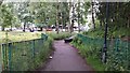
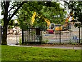
Banana Path approaching Spring Lane
Beyond the trees in the image is the Radcliffe Metrolink site.
Image: © Bradley Michael
Taken: 22 Jun 2015
0.02 miles
2
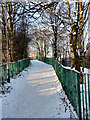
Footpath, Coney Green
Footpath alongside Riverside School (formerly known as Coney Green School); providing access from Spring Lane, and Radcliffe Station, to the Manchester, Bolton & Bury Canal.
Image: © David Dixon
Taken: 22 Dec 2010
0.02 miles
3
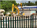
Demolition of High School
Demolition of the former Radcliffe School buildings. The school was built in the early 1970s as Coney Green Technology School, and was merged with Radcliffe High School in 2003 to create Radcliffe Riverside. The school closed in July 2014.
Image: © David Dixon
Taken: 22 Jun 2015
0.03 miles
4
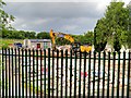
Former Radcliffe Riverside School Site
Demolition of the former Radcliffe School buildings. The school was built in the early 1970s as Coney Green Technology School, and was merged with Radcliffe High School in 2003 to create Radcliffe Riverside. It closed in July 2014.
Image: © David Dixon
Taken: 18 Jun 2015
0.04 miles
5
Demolition Work at Coney Green
Demolition of the former Radcliffe School buildings. The school was built in the early 1970s as Coney Green Technology School, and was merged with Radcliffe High School in 2003 to create Radcliffe Riverside. The school closed in July 2014.
Image: © David Dixon
Taken: 22 Jun 2015
0.04 miles
6
VE Day Celebrations on Spring Lane
2020 saw Bank Holiday Monday celebrated on a Friday as the Government changed the usual holiday date to May 8th to celebrate the 75th anniversary of VE Day. The restrictions imposed to check the spread of the coronavirus pandemic meant that large street parties were prohibited but, nevertheless, people were encouraged to put up decorations and celebrate (as a single household) in their gardens. This house, on Spring Lane, is a typical example. It was later in the evening when I walked past; there was no-one in the garden but the decorations still remained.
Image: © David Dixon
Taken: 8 May 2020
0.04 miles
7

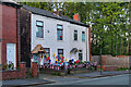
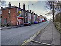
Terraced Houses on Spring Lane
A row of terraced houses (with an off-licence/corner shop at the far end) on Spring Lane, near Radcliffe tram station.
Image: © David Dixon
Taken: 27 Jul 2016
0.04 miles
8
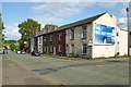
Terraced Houses on Spring Lane
A block of houses on the southern side of Spring Lane.
Image: © David Dixon
Taken: 8 Jun 2020
0.04 miles
10
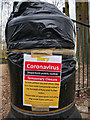
Sealed Wastebin, Spring Lane
During the 2020 Coronavirus outbreak, the local council sealed all the street litter bins in the borough.
Image: © David Dixon
Taken: 31 Mar 2020
0.06 miles