IMAGES TAKEN NEAR TO
East Street, MANCHESTER, M26 2PW
Introduction
This page details the photographs taken nearby to East Street, M26 2PW by members of the Geograph project.
The Geograph project started in 2005 with the aim of publishing, organising and preserving representative images for every square kilometre of Great Britain, Ireland and the Isle of Man.

There are currently over 7.5m images from over14,400 individuals and you can help contribute to the project by visiting https://www.geograph.org.uk
Image Map
Images are licensed for reuse under creativecommons.org/licenses/by-sa/2.0
Notes
- Clicking on the map will re-center to the selected point.
- The higher the marker number, the further away the image location is from the centre of the postcode.
Image Listing (358 Images Found)
Images are licensed for reuse under creativecommons.org/licenses/by-sa/2.0
Image
Details
Distance
1
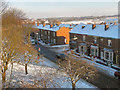
Church Street West/Glebe Street, Radcliffe
The terraced houses on Church Street West, at the corner of Glebe Street. Viewed from the access path to Radcliffe Station.
Image: © David Dixon
Taken: 22 Dec 2010
0.03 miles
2
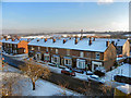
Church Street West, Radcliffe
The terraced houses of Church Street West, seen from the access path to Radcliffe Station.
Image: © David Dixon
Taken: 22 Dec 2010
0.04 miles
3
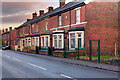
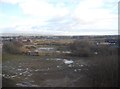
Glebelands
A row of Victorian Terraced houses (dated 1900) on Church Street West.
Image: © David Dixon
Taken: 9 Jan 2021
0.04 miles
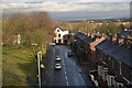
6
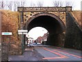
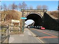
Church Street Railway Bridge
This Bridge used to carry trains over Church Street West. It is now used by the Metrolink trams as they approach Radcliffe Station. The footpath leading to the station is just visible towards the bottom left hand corner of the picture.
Image: © David Dixon
Taken: 17 Jan 2010
0.06 miles
7
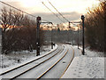
Metrolink Tramway
Looking south from Radcliffe Station across the bridge at Church Street West.
Image: © David Dixon
Taken: 22 Dec 2010
0.06 miles
8
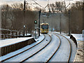
Metrolink Tramway
Altrincham-bound tram approaching the bridge at Church Street West, after leaving Radcliffe Station.
Image: © David Dixon
Taken: 22 Dec 2010
0.06 miles
9
Church Street West bridge
Railway bridge over Church Street West. The railway is now the Metrolink tramline. Access to Radcliffe station is on the left.
Image: © Gerald England
Taken: 18 Feb 2013
0.06 miles
10
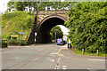
Metrolink Bridge, Church Street West
This former railway bridge on the Bury to Manchester line (now used by Metrolink trams) crosses Church Street West at the northern end of Radcliffe Viaduct, close to Radcliffe Station.
Image: © David Dixon
Taken: 22 Jun 2016
0.06 miles