IMAGES TAKEN NEAR TO
Pollitt Street, MANCHESTER, M26 2GG
Introduction
This page details the photographs taken nearby to Pollitt Street, M26 2GG by members of the Geograph project.
The Geograph project started in 2005 with the aim of publishing, organising and preserving representative images for every square kilometre of Great Britain, Ireland and the Isle of Man.

There are currently over 7.5m images from over14,400 individuals and you can help contribute to the project by visiting https://www.geograph.org.uk
Image Map (Loading...)


Getting Data...Please wait
Leaflet Map data © OpenStreetMap
Images are licensed for reuse under creativecommons.org/licenses/by-sa/2.0
Notes
- Clicking on the map will re-center to the selected point.
- The higher the marker number, the further away the image location is from the centre of the postcode.
Image Listing (333 Images Found)
Images are licensed for reuse under creativecommons.org/licenses/by-sa/2.0
Image
Details
Distance
4
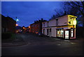
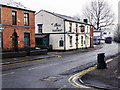
Cock Clod Street
Cock Clod Street off Cross Lane, Radcliffe
M26, near Manchester
Image: © Pete Spooner
Taken: 3 Dec 2010
0.03 miles
9
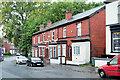
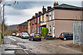
Spring Lane, Brookfield Terrace
Edwardian terraced houses built in 1906.
Image: © David Dixon
Taken: 12 Oct 2021
0.04 miles
10
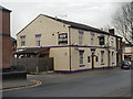
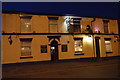
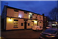
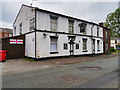
The New Swan
The recently refurbished public house on Spring Lane, now known as "New Swan", was formerly "The Swan & Railway" (Image]).
Image: © David Dixon
Taken: 21 Mar 2013
0.04 miles