IMAGES TAKEN NEAR TO
Birch Street, MANCHESTER, M26 2GA
Introduction
This page details the photographs taken nearby to Birch Street, M26 2GA by members of the Geograph project.
The Geograph project started in 2005 with the aim of publishing, organising and preserving representative images for every square kilometre of Great Britain, Ireland and the Isle of Man.

There are currently over 7.5m images from over14,400 individuals and you can help contribute to the project by visiting https://www.geograph.org.uk
Image Map
Images are licensed for reuse under creativecommons.org/licenses/by-sa/2.0
Notes
- Clicking on the map will re-center to the selected point.
- The higher the marker number, the further away the image location is from the centre of the postcode.
Image Listing (44 Images Found)
Images are licensed for reuse under creativecommons.org/licenses/by-sa/2.0
Image
Details
Distance
1
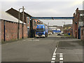
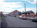
York Street
A delivery lorry outside the Whewell chemicals factory on York Street.
Image: © David Dixon
Taken: 13 Mar 2012
0.03 miles
2
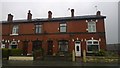
317 to 323 Dumers Lane, Radcliffe
From left to right at 317 through to 323 Dumers Lane in eastern Radcliffe, Greater Manchester, England. These addresses correspond to these red-brick terraced houses, which are typical of Radcliffe, Bury and the wider Greater Manchester region.
Image: © Steven Haslington
Taken: 15 Apr 2015
0.03 miles
5
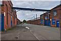
New Bridge Chemical works
J & W Whewell Limited Radcliffe is an independent chemical company in business for more than 100 years. It is situated on the bank of the River Irwell in Radcliffe close to Hardy's Gate Bridge. Shortly after WW2, cart horses owned by the company to deliver their products, would regularly sweep the board of prizes for shire horses in the Bury and District Agricultural Show.
Image: © Dennis Turner
Taken: 28 Oct 2005
0.03 miles
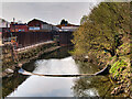
7
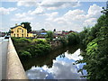
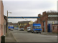
River Irwell
In the background is "The Bridge" and in the centre "New Bridge Chemical Works".
Image: © Alexander P Kapp
Taken: 18 Jul 2007
0.04 miles
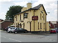
8
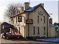
The Bridge
Public house on Dumers Lane, close to the bridge crossing the Irwell
Image: © David Dixon
Taken: 31 Jan 2010
0.04 miles
9
New Flood Defences at Hardy's Gate
Flood defences under construction at the side of York Street. Viewed from Hardy's Gate Bridge.
Image: © David Dixon
Taken: 18 Apr 2021
0.05 miles
10
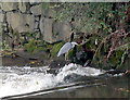
Gone fishing
Obviously a favourite fishing spot for this bird. Image On the weir downstream of Hardy's Gate bridge. The location of this weir is adjacent to the site of the former paper mill and paper bag factory of Bibby & Baron Limited.
Image: © Dennis Turner
Taken: 28 Oct 2005
0.06 miles