IMAGES TAKEN NEAR TO
Lawndale Close, MANCHESTER, M26 1UB
Introduction
This page details the photographs taken nearby to Lawndale Close, M26 1UB by members of the Geograph project.
The Geograph project started in 2005 with the aim of publishing, organising and preserving representative images for every square kilometre of Great Britain, Ireland and the Isle of Man.

There are currently over 7.5m images from over14,400 individuals and you can help contribute to the project by visiting https://www.geograph.org.uk
Image Map
Images are licensed for reuse under creativecommons.org/licenses/by-sa/2.0
Notes
- Clicking on the map will re-center to the selected point.
- The higher the marker number, the further away the image location is from the centre of the postcode.
Image Listing (55 Images Found)
Images are licensed for reuse under creativecommons.org/licenses/by-sa/2.0
Image
Details
Distance
1
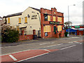
The Swan Hotel
A boarded-up public house on Stand Lane.
Image: © David Dixon
Taken: 7 Apr 2012
0.03 miles
3
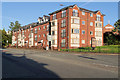
Apartments on New Road
New Road (A665) Radcliffe
Image: © David Dixon
Taken: 20 Jul 2020
0.10 miles
4
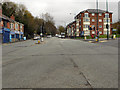
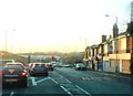
New Road (A665)
The junction of New Road and Stand Lane, from the end of the town centre bypass (Pilkington Way).
Image: © David Dixon
Taken: 6 Apr 2012
0.10 miles
6
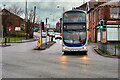
Stand Lane
Go North West 3216 (MX07 BUV), a Volvo B9TL/Wright Eclipse Gemini, negotiates the junction of Stand Lane and Pilkington Way whilst approaching Radcliffe town centre. The bus, which is operating on route number 98 between Manchester and Bury, was repainted in the Go North West livery in June 2020 (https://www.facebook.com/gnwenthusiasts/posts/158955019031448 Go North West) having previously been part of the First Manchester fleet (as number 37304).
Image: © David Dixon
Taken: 18 Jan 2021
0.11 miles
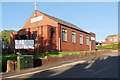
8
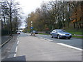
St John's Churchyard, Radcliffe
The church of St John the Evangelist on New Road, Radcliffe was founded in 1866. It closed in 1974 when the parish was combined with St Thomas and worship transferred to Image St John’s Church was demolished in 1976, but its graveyard remains at the side of St John’s Street.
http://heritagephotoarchive.co.uk/p810256090/h4501798A#h4501798a shows a photograph of St John’s Church taken ca 1907.
Image: © David Dixon
Taken: 13 Feb 2014
0.12 miles
9
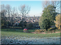
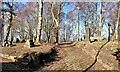
Coronation Park
A corner of the park looking north west over Radcliffe towards the Parish Church of St Thomas
Image: © Dennis Turner
Taken: 18 Nov 2005
0.13 miles
10
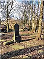
Former Churchyard, St John the Evangelist's Church
The church of St John the Evangelist on New Road, Radcliffe was founded in 1866. It closed in 1974 when the parish was combined with St Thomas and worship transferred to Image St John’s Church was demolished in 1976, but its graveyard remains at the side of St John’s Street.
http://heritagephotoarchive.co.uk/p810256090/h4501798A#h4501798a shows a photograph of St John’s Church taken ca 1907.
Image: © David Dixon
Taken: 13 Feb 2014
0.13 miles