IMAGES TAKEN NEAR TO
Crow Oak, MANCHESTER, M26 1TJ
Introduction
This page details the photographs taken nearby to Crow Oak, M26 1TJ by members of the Geograph project.
The Geograph project started in 2005 with the aim of publishing, organising and preserving representative images for every square kilometre of Great Britain, Ireland and the Isle of Man.

There are currently over 7.5m images from over14,400 individuals and you can help contribute to the project by visiting https://www.geograph.org.uk
Image Map
Images are licensed for reuse under creativecommons.org/licenses/by-sa/2.0
Notes
- Clicking on the map will re-center to the selected point.
- The higher the marker number, the further away the image location is from the centre of the postcode.
Image Listing (20 Images Found)
Images are licensed for reuse under creativecommons.org/licenses/by-sa/2.0
Image
Details
Distance
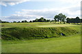
1
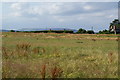
Open land at Chapel Field
In the distance is Holcombe Hill with Peel Tower on it.
Image: © Bill Boaden
Taken: 26 Jul 2011
0.09 miles
2
New Road
Imaginatively named road connecting Radcliffe and Whitefield.
Image: © Dennis Turner
Taken: 18 Nov 2005
0.16 miles
3
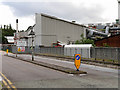
Polyflor Factory, Leicester Road
Based in Whitefield, Polyflor is a major manufacturer of commercial floorcoverings.
Image: © David Dixon
Taken: 29 Jun 2016
0.16 miles
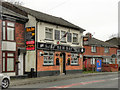
4
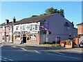
New Bay
Public house on Stand Lane at Chapelfield.
Image: © David Dixon
Taken: 5 Jul 2014
0.17 miles
5
New Bay
Public house on Stand Lane at Chapelfield.
Image: © David Dixon
Taken: 8 Apr 2012
0.18 miles
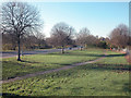
6
Stand Golf Club
Seen through the fence bars lining a footpath to Chapel Field.
Image: © Bill Boaden
Taken: 26 Jul 2011
0.18 miles
7
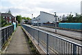
Leicester Road, Whitefield
Ahead is the Polyflor factory. In the foreground is a bridge over the Metrolink line between Whitefield and Radcliffe.
Image: © Bill Boaden
Taken: 26 Jul 2011
0.18 miles
9
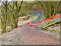
Path Closed in Springwater Park
The path into Springwater Park from Radcliffe New Road has been closed because of a landslip caused by recent heavy rain and flooding of the River Irwell https://twitter.com/LoveWhitefield/status/1253309190619033600 .
Image: © David Dixon
Taken: 1 Feb 2021
0.19 miles
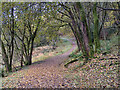
10
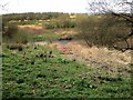
Springwater Park
A glimpse of the River Irwell from the path leading down the hill from Radcliffe New Road.
Image: © David Dixon
Taken: 9 Apr 2014
0.20 miles