IMAGES TAKEN NEAR TO
Stand Lane, MANCHESTER, M26 1NW
Introduction
This page details the photographs taken nearby to Stand Lane, M26 1NW by members of the Geograph project.
The Geograph project started in 2005 with the aim of publishing, organising and preserving representative images for every square kilometre of Great Britain, Ireland and the Isle of Man.

There are currently over 7.5m images from over14,400 individuals and you can help contribute to the project by visiting https://www.geograph.org.uk
Image Map
Images are licensed for reuse under creativecommons.org/licenses/by-sa/2.0
Notes
- Clicking on the map will re-center to the selected point.
- The higher the marker number, the further away the image location is from the centre of the postcode.
Image Listing (354 Images Found)
Images are licensed for reuse under creativecommons.org/licenses/by-sa/2.0
Image
Details
Distance
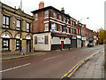
2
Radcliffe, Bank Street
Looking along Bank Street. In the background, the tower of St Thomas' Church Image] (on the other side of the River Irwell) can be seen.
Image: © David Dixon
Taken: 3 Nov 2012
0.02 miles
3
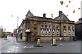
Italia Mia, Radcliffe
The building, on the corner of Stand Lane and Milltown Street, was originally a branch of the Lancashire and Yorkshire Bank Ltd.
Image: © philandju
Taken: 5 Nov 2013
0.02 miles
4
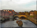
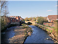
Radcliffe Bridge
Looking upstream from Pilkington Way towards Radcliffe Bridge.
The first bridge across the Irwell, at this site, was probably erected during the late Mediæval period at the site of a ford where, the Manchester to Blackburn packhorse route (now Blackburn Street) passed through the hamlet which became known as Radcliffe Bridge.
http://en.wikipedia.org/wiki/File:Radcliffe_Bridge.jpg - The first known photograph of Radcliffe Bridge, taken around 1854.
Image: © David Dixon
Taken: 13 Nov 2011
0.03 miles
5
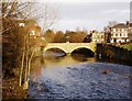
Radcliffe Bridge, River Irwell
Looking upstream from Pilkington Way towards Radcliffe Bridge.
The first bridge across the Irwell, at this site, was probably erected during the late Mediæval period at the site of a ford where the Manchester to Blackburn packhorse route (now Blackburn Street) passed through the hamlet which later became known as Radcliffe Bridge. Until the town centre by-pass (Pilkington Way) was constructed in the late 1980s, Radcliffe Bridge carried all the traffic across the Irwell as it passed through Radcliffe towards Bolton and beyond.
http://en.wikipedia.org/wiki/File:Radcliffe_Bridge.jpg - The first known photograph of Radcliffe Bridge, taken around 1854.
Image: © David Dixon
Taken: 8 Apr 2020
0.03 miles
6
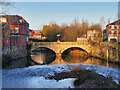
River Irwell, Radcliffe Bridge
Looking upstream from Pilkington Way towards Radcliffe Bridge.
The first bridge across the Irwell, at this site, was probably erected during the late Mediæval period at the site of a ford where the Manchester to Blackburn packhorse route (now Blackburn Street) passed through the hamlet which became known as Radcliffe Bridge.
http://en.wikipedia.org/wiki/File:Radcliffe_Bridge.jpg - The first known photograph of Radcliffe Bridge, taken around 1854.
Image: © David Dixon
Taken: 29 Dec 2020
0.03 miles
7
River Irwell, Radcliffe Bridge.
Until the town centre by-pass (Pilkington Way) was constructed in the late 1980s, this bridge carried traffic across the Irwell as it passed through Radcliffe towards Bolton and beyond.
Image: © David Dixon
Taken: 17 Jan 2010
0.03 miles
8

River Irwell, Radcliffe Bridge
Viewed from the riverside walk between Pilkington Way and Radcliffe bridge at Blackburn Street.
Image: © David Dixon
Taken: 17 Jan 2010
0.03 miles
9
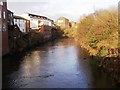
River Irwell
River Irwell as it passes through Radcliffe. Looking northwards (upstream) from Blackburn Street Bridge.
Image: © David Dixon
Taken: 17 Jan 2010
0.03 miles
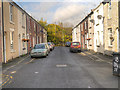
10
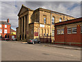
Bridge Methodist Church, Milltown Street
An impressive building, built in 1905. A pity that it is tucked away in Milltown Street, behind the library, and not directly visible from the town centre.
Image: © David Dixon
Taken: 20 Mar 2016
0.03 miles