IMAGES TAKEN NEAR TO
New Road, MANCHESTER, M26 1LS
Introduction
This page details the photographs taken nearby to New Road, M26 1LS by members of the Geograph project.
The Geograph project started in 2005 with the aim of publishing, organising and preserving representative images for every square kilometre of Great Britain, Ireland and the Isle of Man.

There are currently over 7.5m images from over14,400 individuals and you can help contribute to the project by visiting https://www.geograph.org.uk
Image Map
Images are licensed for reuse under creativecommons.org/licenses/by-sa/2.0
Notes
- Clicking on the map will re-center to the selected point.
- The higher the marker number, the further away the image location is from the centre of the postcode.
Image Listing (110 Images Found)
Images are licensed for reuse under creativecommons.org/licenses/by-sa/2.0
Image
Details
Distance
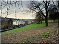
2
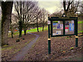
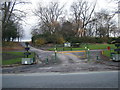
Coronation Park, Radcliffe
Coronation Park is a small urban local community park of approximately 3.53 hectares, located a short distance from Radcliffe Bridge near the town centre. It opened in 1900 (so presumably was named for the coronation of King Edward VII) having been created on land donated by the Earl of Derby http://friendsofclosepark.btck.co.uk/Thehistoryofourcommunityandpark . It is situated on a steep hill and has well-maintained footways.
The park was used in the 1962 film “A Kind of Loving” https://en.wikipedia.org/wiki/A_Kind_of_Loving_(film)#Awards (as “Beacon’s Park” where Vic meets Ingrid).
Image: © David Dixon
Taken: 2 Jan 2016
0.05 miles
3
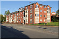
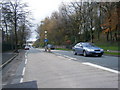
Apartments on New Road
New Road (A665) Radcliffe
Image: © David Dixon
Taken: 20 Jul 2020
0.05 miles
4
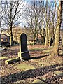
St John's Churchyard, Radcliffe
The church of St John the Evangelist on New Road, Radcliffe was founded in 1866. It closed in 1974 when the parish was combined with St Thomas and worship transferred to Image St John’s Church was demolished in 1976, but its graveyard remains at the side of St John’s Street.
http://heritagephotoarchive.co.uk/p810256090/h4501798A#h4501798a shows a photograph of St John’s Church taken ca 1907.
Image: © David Dixon
Taken: 13 Feb 2014
0.05 miles
6
Former Churchyard, St John the Evangelist's Church
The church of St John the Evangelist on New Road, Radcliffe was founded in 1866. It closed in 1974 when the parish was combined with St Thomas and worship transferred to Image St John’s Church was demolished in 1976, but its graveyard remains at the side of St John’s Street.
http://heritagephotoarchive.co.uk/p810256090/h4501798A#h4501798a shows a photograph of St John’s Church taken ca 1907.
Image: © David Dixon
Taken: 13 Feb 2014
0.07 miles
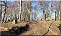
8
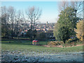
Coronation Park
A corner of the park looking north west over Radcliffe towards the Parish Church of St Thomas
Image: © Dennis Turner
Taken: 18 Nov 2005
0.07 miles
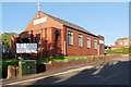
9
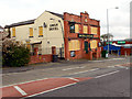
The Swan Hotel
A boarded-up public house on Stand Lane.
Image: © David Dixon
Taken: 7 Apr 2012
0.08 miles
10
Coronation Park, Behind Irwell Street
Coronation Park is a small urban local community park of approximately 3.53 hectares, located a short distance from Radcliffe Bridge near the town centre. It opened in 1900 (so presumably was named for the coronation of King Edward VII) having been created on land donated by the Earl of Derby http://friendsofclosepark.btck.co.uk/Thehistoryofourcommunityandpark . It is situated on a steep hill and has well-maintained footways.
The park was used in the 1962 film “A Kind of Loving” https://en.wikipedia.org/wiki/A_Kind_of_Loving_(film)#Awards (as “Beacon’s Park” where Vic meets Ingrid).
Image: © David Dixon
Taken: 2 Jan 2016
0.08 miles