IMAGES TAKEN NEAR TO
Chapel Street, MANCHESTER, M26 1FP
Introduction
This page details the photographs taken nearby to Chapel Street, M26 1FP by members of the Geograph project.
The Geograph project started in 2005 with the aim of publishing, organising and preserving representative images for every square kilometre of Great Britain, Ireland and the Isle of Man.

There are currently over 7.5m images from over14,400 individuals and you can help contribute to the project by visiting https://www.geograph.org.uk
Image Map
Images are licensed for reuse under creativecommons.org/licenses/by-sa/2.0
Notes
- Clicking on the map will re-center to the selected point.
- The higher the marker number, the further away the image location is from the centre of the postcode.
Image Listing (41 Images Found)
Images are licensed for reuse under creativecommons.org/licenses/by-sa/2.0
Image
Details
Distance
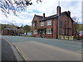
1
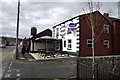
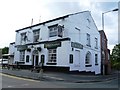
Market Street Tavern, Stoneclough
On the main thoroughfare through Stoneclough.
Image: © philandju
Taken: 5 Apr 2013
0.03 miles
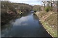
4
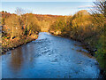
River Irwell at Prestolee
View downstream from Prestolee "New" Bridge.
Image: © David Dixon
Taken: 27 Feb 2021
0.08 miles
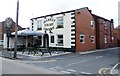
6
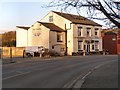
The Grapes
Stoneclough Road/Market Street
Image: © David Dixon
Taken: 14 Mar 2010
0.10 miles
7
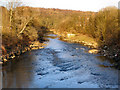
River Irwell
Looking eastwards (downstream) from Prestolee bridge.
Image: © David Dixon
Taken: 14 Mar 2010
0.10 miles
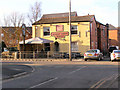
8
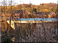
Prestolee New Bridge
Carrying Bridge Street over the River Irwell.
Image: © David Dixon
Taken: 14 Mar 2010
0.11 miles
10
The River Irwell at Prestolee
From the bridge on Church Street.
Image: © philandju
Taken: 5 Apr 2013
0.14 miles