IMAGES TAKEN NEAR TO
Kearsley Road, MANCHESTER, M26 1FA
Introduction
This page details the photographs taken nearby to Kearsley Road, M26 1FA by members of the Geograph project.
The Geograph project started in 2005 with the aim of publishing, organising and preserving representative images for every square kilometre of Great Britain, Ireland and the Isle of Man.

There are currently over 7.5m images from over14,400 individuals and you can help contribute to the project by visiting https://www.geograph.org.uk
Image Map
Images are licensed for reuse under creativecommons.org/licenses/by-sa/2.0
Notes
- Clicking on the map will re-center to the selected point.
- The higher the marker number, the further away the image location is from the centre of the postcode.
Image Listing (7 Images Found)
Images are licensed for reuse under creativecommons.org/licenses/by-sa/2.0
Image
Details
Distance
1
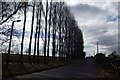
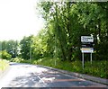
Line of Poplars on Ringley Road
At Cinder Hill.
Image: © philandju
Taken: 5 Apr 2013
0.13 miles
2
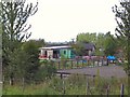
Cinder Hill Farmland
As one climbs the hill out of Stoneclough, these buildings are at the summit of Cinder Hill, on the right at Ringley.
Image: © Roger May
Taken: 24 Aug 2005
0.15 miles
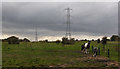
5

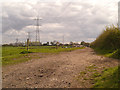
Irwell Valley, Shore Top Farm
A view looking across the Irwell Valley. Looking from the towpath of the Manchester, Bolton and Bury Canal towards Shore Top Farm (SD 7691 0603).
Image: © David Dixon
Taken: 11 Jul 2012
0.20 miles
6

Irwell Valley
A view from the towpath of the Manchester, Bolton and Bury Canal; looking towards Ringley Road, on the other side of the Irwell Valley.
Image: © David Dixon
Taken: 11 Jul 2012
0.21 miles