IMAGES TAKEN NEAR TO
Prestolee Road, MANCHESTER, M26 1EF
Introduction
This page details the photographs taken nearby to Prestolee Road, M26 1EF by members of the Geograph project.
The Geograph project started in 2005 with the aim of publishing, organising and preserving representative images for every square kilometre of Great Britain, Ireland and the Isle of Man.

There are currently over 7.5m images from over14,400 individuals and you can help contribute to the project by visiting https://www.geograph.org.uk
Image Map
Images are licensed for reuse under creativecommons.org/licenses/by-sa/2.0
Notes
- Clicking on the map will re-center to the selected point.
- The higher the marker number, the further away the image location is from the centre of the postcode.
Image Listing (98 Images Found)
Images are licensed for reuse under creativecommons.org/licenses/by-sa/2.0
Image
Details
Distance
1
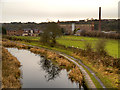
Manchester, Bolton and Bury Canal at Prestolee
Looking south, from Seddons Fold Bridge. The large mill in the background is the Grade II listed Prestolee Mill (also known as Kearsley Mill). It was built in 1906.
Image: © David Dixon
Taken: 26 Dec 2012
0.04 miles
2

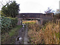
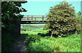
Appleyard Bridge
Manchester, Bolton & Bury Canal, towards Appleyard Bridge (No 11). The canal is heavily overgrown here but there is water below the weeds.
Bridge No 11 is approx 320 yards south of Bridge 13. There was no evidence of a bridge 12 in between them.
Image: © David Dixon
Taken: 14 Nov 2010
0.07 miles
3
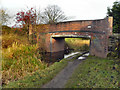
Appleyard Bridge, Prestolee
Bridge No 11 on the Manchester, Bolton & Bury Canal, looking in the direction of Nob End.
Image: © David Dixon
Taken: 14 Nov 2010
0.07 miles
4
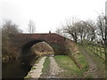
Manchester, Bolton & Bury Canal, Appleyard Bridge
A short stretch of canal below Appleyard Bridge is not overgrown. Compare this with Image] and Image], taken nearby.
Image: © David Dixon
Taken: 14 Nov 2010
0.07 miles
7
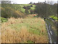
Dickie's Bridge, Manchester Bolton and Bury Canal
Dickie's Bridge does not appear to have a right of way over it, but it is part of a traffic-free cycle route, according to OS.
Image: © Dr Neil Clifton
Taken: 26 May 1992
0.08 miles

9
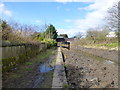
Canal near Prestolee road Bridge
Some clearance work in evidence clearing the choked canal bed
Image: © Raymond Knapman
Taken: 4 Apr 2015
0.09 miles
10
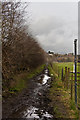
Manchester, Bolton and Bury Canal, Prestolee
Looking South from Image This might look like a field, but the canal still has water here. The towpath can be seen on the right.
Image: © David Dixon
Taken: 14 Nov 2010
0.10 miles