IMAGES TAKEN NEAR TO
Outwood Road, MANCHESTER, M26 1BQ
Introduction
This page details the photographs taken nearby to Outwood Road, M26 1BQ by members of the Geograph project.
The Geograph project started in 2005 with the aim of publishing, organising and preserving representative images for every square kilometre of Great Britain, Ireland and the Isle of Man.

There are currently over 7.5m images from over14,400 individuals and you can help contribute to the project by visiting https://www.geograph.org.uk
Image Map
Images are licensed for reuse under creativecommons.org/licenses/by-sa/2.0
Notes
- Clicking on the map will re-center to the selected point.
- The higher the marker number, the further away the image location is from the centre of the postcode.
Image Listing (11 Images Found)
Images are licensed for reuse under creativecommons.org/licenses/by-sa/2.0
Image
Details
Distance
1
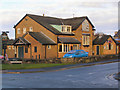
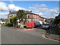
Hare and Hounds, Outwood
The Hare and Hounds pub at the corner of Ringley Road and Outwood Road.
Image: © David Dixon
Taken: 29 Jan 2010
0.08 miles
3
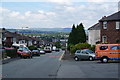
Outwood Road, Radcliffe
The road descends into the Irwell valley where the town centre is. In the distance is Holcombe Moor.
Image: © Bill Boaden
Taken: 7 Jul 2012
0.09 miles
4
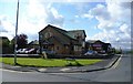
Ringley Road West
At the junction with Outwood Road to the right, where The Hare & Hounds pub is situated.
Image: © Bradley Michael
Taken: 9 Sep 2015
0.10 miles
6
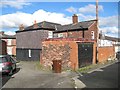
Hanging slate work, Rupert Street
The end of this terrace of houses has very unusual and decorative slate-cladding for protection from the elements. While hanging slates are fairly common, this level of deliberate decoration is exceptional and to be congratulated.
Image: © Jonathan Wilkins
Taken: 23 Oct 2016
0.21 miles
8
Rupert Street
A fine Monkey-puzzle tree at the junction of Outwood Road and Rupert Street.
Image: © Jonathan Wilkins
Taken: 23 Oct 2016
0.23 miles
9
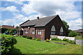
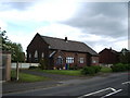
Converted chapel on Ringley Road West
This is still marked as a chapel on the map. It was formerly St Paul's Church. St Aidan's Mission Church used to be next door and was closed and demolished following a fire in 1987.
Image: © Bill Boaden
Taken: 7 Jul 2012
0.24 miles
10
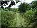
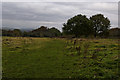
Footpath
Footpath from Chapel Field to Outwood Gate, Under all that freshly cut grass is the remains of a cobble stoned path or road, but now it can only be called a path
Image: © Alexander P Kapp
Taken: 16 Jul 2007
0.24 miles