IMAGES TAKEN NEAR TO
Peter Street, MANCHESTER, M2 5GB
Introduction
This page details the photographs taken nearby to Peter Street, M2 5GB by members of the Geograph project.
The Geograph project started in 2005 with the aim of publishing, organising and preserving representative images for every square kilometre of Great Britain, Ireland and the Isle of Man.

There are currently over 7.5m images from over14,400 individuals and you can help contribute to the project by visiting https://www.geograph.org.uk
Image Map (Loading...)


Getting Data...Please wait
Leaflet Map data © OpenStreetMap
Images are licensed for reuse under creativecommons.org/licenses/by-sa/2.0
Notes
- Clicking on the map will re-center to the selected point.
- The higher the marker number, the further away the image location is from the centre of the postcode.
Image Listing (2560 Images Found)
Images are licensed for reuse under creativecommons.org/licenses/by-sa/2.0
Image
Details
Distance
1
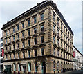
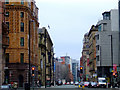
Harvester House, Peter Street, Manchester
Very imposing Classical stone-faced warehouse, by Clegg & Knowles, c1868. Diminishing decoration to the windows and rusticated arcades to the ground floor. Grade II listed.
It was built for Ralli Brothers, shipping merchants. Now retail outlet at street level (occupants at the time of the photo, Double Take Studios, have since gone into administration), and offices above.
Image: © Stephen Richards
Taken: 25 Jul 2011
0.01 miles
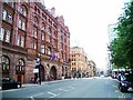
2

47 Peter Street, Manchester
Aka Lancashire House. A very nice palazzo warehouse by Walters, Barker & Ellis, c1868. The windows are treated differently on each floor - the second has an elegant arcade formed by impost bands. Grade II listed.
Part of the ground floor appears to have been faced in granite or marble. Offices to let at the time of the photo.
Image: © Stephen Richards
Taken: 23 Jul 2011
0.01 miles
3
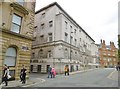
29 Peter Street, Manchester
Aka Petersfield House. Built 1965 to the designs of Howitt & Tucker.
At the time of the photo, occupied by a careers office for the armed forces.
Image: © Stephen Richards
Taken: 23 Jul 2011
0.01 miles
5
Manchester, former Police HQ
At the corner of Southmill & Bootle Streets, in an area threatened with redevelopment. http://manchesterhistory.net/manchester/tours/tour6/area6page33.html http://www.manchestereveningnews.co.uk/business/business-news/gary-neville-st-michaels-development-11672817
Image: © Mike Faherty
Taken: 29 Jul 2017
0.02 miles
6
Peter Street
Mount Street is to the left, viewed from St Peter's Square.
Image: © Thomas Nugent
Taken: 28 Feb 2011
0.02 miles
7
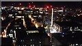
Manchester at Night
View down Peter Street towards Central Library and Oxford Street from the rooftop of No.1 Spinningfields, Hardman Square
Image: © Anthony Parkes
Taken: 24 Mar 2018
0.02 miles
8
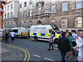
Police vehicles
There was a large police presence for the vigil in Albert Square, and the streets round about were full of vehicles in readiness.
Image: © Bob Harvey
Taken: 23 May 2017
0.02 miles
9
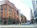
Peter Street, Manchester
Hard to believe this was taken around 12-00pm on a Friday in a major city where's all the traffic!? 100 years ago the place would have been jammed with horse-drawn carts, trams, cars, people and every mortal thing. Credit Crunch!! Looks the end of the world to me!
Image: © Stanley Walker
Taken: 26 Sep 2008
0.02 miles
10
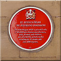
Peterloo Massacre Commemoration Plaque
This red plaque, attached to the outside of the former Free Trade Hall (Image]), notes that it was built on the site of the Peterloo Massacre of 1819.
ST PETER'S FIELDS
THE PETERLOO MASSACRE
On 16th August 1819, a peaceful rally
of 60,000 pro-democracy reformers,
men, women and children,
was attacked by armed cavalry
resulting in 15 deaths and
over 600 injuries.
Image: © David Dixon
Taken: 14 Oct 2012
0.02 miles