IMAGES TAKEN NEAR TO
Chapel Road, MANCHESTER, M25 9SR
Introduction
This page details the photographs taken nearby to Chapel Road, M25 9SR by members of the Geograph project.
The Geograph project started in 2005 with the aim of publishing, organising and preserving representative images for every square kilometre of Great Britain, Ireland and the Isle of Man.

There are currently over 7.5m images from over14,400 individuals and you can help contribute to the project by visiting https://www.geograph.org.uk
Image Map
Images are licensed for reuse under creativecommons.org/licenses/by-sa/2.0
Notes
- Clicking on the map will re-center to the selected point.
- The higher the marker number, the further away the image location is from the centre of the postcode.
Image Listing (40 Images Found)
Images are licensed for reuse under creativecommons.org/licenses/by-sa/2.0
Image
Details
Distance
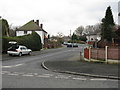
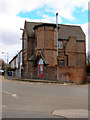
1

Rainsough Arms - an ex-pub
Big screen TV was evidently not enough to save the township's only pub.
Image: © Peter Whatley
Taken: 28 Feb 2009
0.10 miles
4
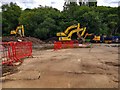
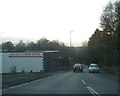
Cussons Soap factory
The redevelopment of the old Cussons Soap factory site for housing.
Image: © Peter McDermott
Taken: 20 Jun 2020
0.11 miles
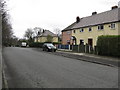
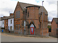
7
The Plough
The Plough public house on Rainsough Brow.
Image: © Peter McDermott
Taken: 22 Nov 2014
0.12 miles
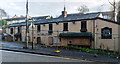
8
Rainsough Community Centre
Former church at the corner of Kersal Road and Rainsough Brow.
Image: © David Dixon
Taken: 27 Mar 2010
0.12 miles
9
Rainsough Community Centre
Former church at the corner of Rainsough Brow and Kersal Road
Image: © David Dixon
Taken: 27 Mar 2010
0.13 miles
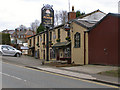
10
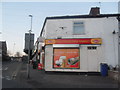
Prestwich Mini Market - Rainsough Brow
Image: © Anthony Parkes
Taken: 7 Mar 2011
0.13 miles