IMAGES TAKEN NEAR TO
St. Anns Road, MANCHESTER, M25 9QE
Introduction
This page details the photographs taken nearby to St. Anns Road, M25 9QE by members of the Geograph project.
The Geograph project started in 2005 with the aim of publishing, organising and preserving representative images for every square kilometre of Great Britain, Ireland and the Isle of Man.

There are currently over 7.5m images from over14,400 individuals and you can help contribute to the project by visiting https://www.geograph.org.uk
Image Map
Images are licensed for reuse under creativecommons.org/licenses/by-sa/2.0
Notes
- Clicking on the map will re-center to the selected point.
- The higher the marker number, the further away the image location is from the centre of the postcode.
Image Listing (59 Images Found)
Images are licensed for reuse under creativecommons.org/licenses/by-sa/2.0
Image
Details
Distance
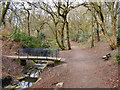
2
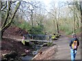
Prestwich Clough
The steep, wooded valley at the head of Prestwich Clough.
Image: © David Dixon
Taken: 6 Mar 2021
0.04 miles
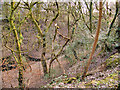
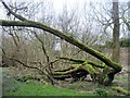
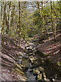
5
Prestwich Clough
Below the graveyard of St. Mary's Church is a wooded area with a stream running through it, known as Prestwich Clough.
Image: © Tricia Neal
Taken: 26 Feb 2014
0.06 miles
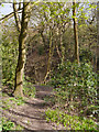
6
Prestwich Clough, Manchester
This is a wooded area with a small street, alongside St. Mary's Church.
Image: © Tricia Neal
Taken: 26 Feb 2014
0.08 miles
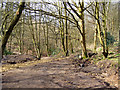
7
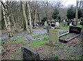
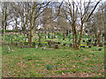
St. Mary's Churchyard, Prestwich
The churchyard blends into the woodland of Prestwich Clough. The area immediately beside the Church is flat, but it then slopes down towards a brook and the trees become more frequent, as it blends into the surrounding woodland.
Image: © Tricia Neal
Taken: 26 Feb 2014
0.10 miles
9
Prestwich St Mary's Church and Graveyard
The hill to the south of the church.
Image: © David Dixon
Taken: 8 Apr 2010
0.11 miles
10
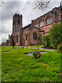
The Parish Church of St Mary the Virgin, Prestwich
The south face of St Mary's Church which is a Grade I listed building. It is built in local Lancashire red sandstone.
Image: © David Dixon
Taken: 13 Apr 2012
0.12 miles