IMAGES TAKEN NEAR TO
Prestwich Hills, MANCHESTER, M25 9PY
Introduction
This page details the photographs taken nearby to Prestwich Hills, M25 9PY by members of the Geograph project.
The Geograph project started in 2005 with the aim of publishing, organising and preserving representative images for every square kilometre of Great Britain, Ireland and the Isle of Man.

There are currently over 7.5m images from over14,400 individuals and you can help contribute to the project by visiting https://www.geograph.org.uk
Image Map (Loading...)


Getting Data...Please wait
Leaflet Map data © OpenStreetMap
Images are licensed for reuse under creativecommons.org/licenses/by-sa/2.0
Notes
- Clicking on the map will re-center to the selected point.
- The higher the marker number, the further away the image location is from the centre of the postcode.
Image Listing (10 Images Found)
Images are licensed for reuse under creativecommons.org/licenses/by-sa/2.0
Image
Details
Distance
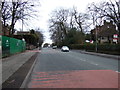
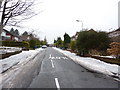
1
Butterstile Lane, Prestwich
Behind the camera position there stands a (comparatively) rare Edward VIII post box.
Image: © philandju
Taken: 5 Oct 2011
0.13 miles
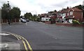
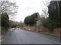
2
Sandy Meade, Prestwich
A residential street off Sandy Lane.
Image: © philandju
Taken: 5 Oct 2011
0.16 miles
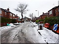
3
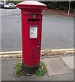
Edward VIII post box
On Butterstile Lane in Prestwich, the box is one of only approximately 200 in the country with the Edward VIII royal cipher.
Image: © philandju
Taken: 5 Oct 2011
0.17 miles
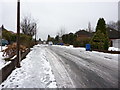
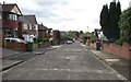
9
Prestwich Park Road South, Prestwich
Image: © Alexander P Kapp
Taken: 15 Jan 2010
0.25 miles