IMAGES TAKEN NEAR TO
Hillside Avenue, MANCHESTER, M25 9AE
Introduction
This page details the photographs taken nearby to Hillside Avenue, M25 9AE by members of the Geograph project.
The Geograph project started in 2005 with the aim of publishing, organising and preserving representative images for every square kilometre of Great Britain, Ireland and the Isle of Man.

There are currently over 7.5m images from over14,400 individuals and you can help contribute to the project by visiting https://www.geograph.org.uk
Image Map
Images are licensed for reuse under creativecommons.org/licenses/by-sa/2.0
Notes
- Clicking on the map will re-center to the selected point.
- The higher the marker number, the further away the image location is from the centre of the postcode.
Image Listing (26 Images Found)
Images are licensed for reuse under creativecommons.org/licenses/by-sa/2.0
Image
Details
Distance
1
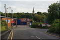
Sedgley Park Trading Estate
St Paul's, Kersal stands behind.
Image: © Bill Boaden
Taken: 4 Sep 2012
0.11 miles
3
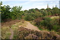
Kersal Moor
A surprisingly wild enclave complete with heather. St Paul's, Kersal is showing behind.
Image: © Bill Boaden
Taken: 4 Sep 2012
0.16 miles
4
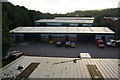
Sedgley Park Trading Estate
Viewed from the Carphone Warehouse car park and looking towards a lowering sun.
Image: © Bill Boaden
Taken: 4 Sep 2012
0.17 miles
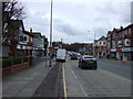
6
The A56 at Prestwich near Mountheath
Image: © Raymond Knapman
Taken: 26 Jan 2012
0.17 miles
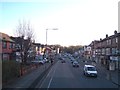
7
Bury New Road (A56)
Heading south towards Manchester.
Image: © JThomas
Taken: 16 Mar 2013
0.17 miles
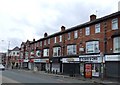
8
Bury New Road, Sedgley Park, Manchester
Taken on Bury New Road looking towards Manchester. Kings Road goes off on the left, and George Street on the right.
Image: © Tricia Neal
Taken: 19 Feb 2014
0.18 miles
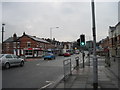
9
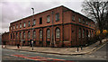
Prestwich Telephone Exchange
Prestwich Telephone Exchange on Bury New Road, Hilton Park, Prestwich.
Image: © Peter McDermott
Taken: 16 Mar 2014
0.18 miles
10
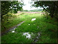
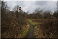
Kersal Moor in the wet
The path forks just after entering Kersal Moor from the Moor Lane entrance at the St Paul's Church end and this is the pathway to the left. And here is ample evidence of a very wet summer.
Image: © Carroll Pierce
Taken: 26 Aug 2012
0.18 miles