IMAGES TAKEN NEAR TO
M25 6HJ
Introduction
This page details the photographs taken nearby to M25 6HJ by members of the Geograph project.
The Geograph project started in 2005 with the aim of publishing, organising and preserving representative images for every square kilometre of Great Britain, Ireland and the Isle of Man.

There are currently over 7.5m images from over14,400 individuals and you can help contribute to the project by visiting https://www.geograph.org.uk
Image Map
Images are licensed for reuse under creativecommons.org/licenses/by-sa/2.0
Notes
- Clicking on the map will re-center to the selected point.
- The higher the marker number, the further away the image location is from the centre of the postcode.
Image Listing (15 Images Found)
Images are licensed for reuse under creativecommons.org/licenses/by-sa/2.0
Image
Details
Distance
1
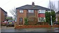
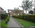
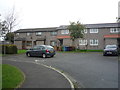
40 Kenmore Road, Whitefield
40 Kenmore Road in Whitefield, Greater Manchester, is a post-war semi-detached home typical of suburban Whitefield.
Image: © Steven Haslington
Taken: 9 Mar 2015
0.08 miles
2
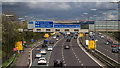
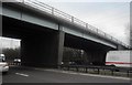
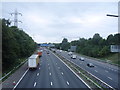
M60 Motorway
The M60 Motorway approaching the junction with the M66 and the M62.
Image: © Peter McDermott
Taken: 3 May 2015
0.15 miles
3
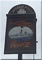
Sign for the Frigate public house, Whitefield
Image: © JThomas
Taken: 10 Sep 2018
0.17 miles
4
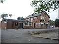
The Frigate public house, Whitefield
On Thatch Leach Lane.
Image: © JThomas
Taken: 10 Sep 2018
0.18 miles
5
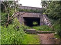
M60
The Haweswater Aqueduct crossing under the M60.
Image: © Peter McDermott
Taken: 11 Jun 2020
0.19 miles
9
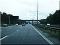
The M60 Motorway, Whitefield
Looking south west from the bridge on Sandgate Road.
Image: © JThomas
Taken: 10 Sep 2018
0.23 miles