IMAGES TAKEN NEAR TO
Farm Hill, Clifton Road, MANCHESTER, M25 3JX
Introduction
This page details the photographs taken nearby to Farm Hill, Clifton Road, M25 3JX by members of the Geograph project.
The Geograph project started in 2005 with the aim of publishing, organising and preserving representative images for every square kilometre of Great Britain, Ireland and the Isle of Man.

There are currently over 7.5m images from over14,400 individuals and you can help contribute to the project by visiting https://www.geograph.org.uk
Image Map
Images are licensed for reuse under creativecommons.org/licenses/by-sa/2.0
Notes
- Clicking on the map will re-center to the selected point.
- The higher the marker number, the further away the image location is from the centre of the postcode.
Image Listing (3 Images Found)
Images are licensed for reuse under creativecommons.org/licenses/by-sa/2.0
Image
Details
Distance
1
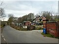
Former gas works site
Several of the outbuildings used as stables at Avon Cottage on Clifton Road appear to be from the original gas works.
Image: © Kevin Waterhouse
Taken: 14 Feb 2023
0.11 miles
2
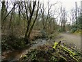
Bradley Brook
In Mere Clough at Ox Gap, Prestwich
Image: © Kevin Waterhouse
Taken: 14 Feb 2023
0.12 miles
3
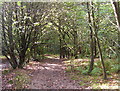
By Philips Park
Looking in a southerly direction into the valley that contains the course of Bradley Brook. Taken close to the footbridge that spans the M60 motorway.
Image: © Keith Williamson
Taken: 19 Sep 2006
0.20 miles